Showing posts with label volcanoes. Show all posts

Tuesday, December 31, 2024

M4-M5 earthquakes in the Awash area of Ethiopia (late 2024)

There have been numerous M4-M5 earthquakes in the Awash area of Ethiopia over the last few months. This is within the Main Ethiopia Rift at its NE end where it begins to open into the Afar. There is a young volcano Fentale in that area which had an eruption last in 1820.

Nice post fromn the Euro-Mediterranean Seismological Centre (EMSC): SUMMARY

Here is a live link of that area: LINK--last 24 hours
Here is the same area: LINK--7 days

That would also mean that there have been many smaller events (Gutenberg-Richter law suggests 10x for each integer decrease in magnitude). The global seismic networks the USGS uses have an M4 cutoff outside the US. These are shallow events (10km default depth). I would bet they are even shallower but that is all the network location can provide.

No doubt the Main Ethiopian Rift is active and extending NW-SE a few mm/yr (hence the NE-SW trending faults in the area). So, we should not be surprised to see the events. The focal mechanisms (directionality of first motions) are consistent with motion along those faults.

The location accuracy is probably only good to 5-10 km so these events might actually be more well aligned with themselves and faults in the area instead of the cloud in the map above.

What is intriguing to me is that it is a swarm. I would not be surprised if there were also some interaction with the magmatic system of the Fentale to Mt. Dofan. I note the InSAR data in this LINK that seems consistent with intrusions along the rift NE of Fantale. Here is footage of an eruption on January 3, 2025 in the area NE of Fantale (Mt. Dofan) where the more recent events have occured: LINK. Thanks to Amy Rector for the link.

It is interesting and certainly in the near field, these events could damage unreinforced masonry structures as well as frighten people and animals. These events have been felt in Addis Ababa (~200 km distance) as moderate to weak shaking.

Links:

Wednesday, November 25, 2020

Warford Ranch volcano (Arizona) sUAS mapping

Introduction

We recently visited the Warford Ranch Volcano which is a low shield volcano that is part of the Sentinel-Arlington volcanic field of southwestern Arizona. It is about 3 million years old. It was a favorite field trip destination of Prof. Ronald Greeley. Shelby Cave worked on the Sentinel-Arlington field for her Ph.D. dissertation under the supervision of Prof. Greeley and after his passing she worked with Prof. Amanda Clarke.

Google maps location for Warford Ranch (NW of Gila Bend, AZ).

Professor Clarke is teaching the Advanced Field Geology course and she took the group to Warford Ranch volcano to examine its volcanology. I did some UAS-mapping to help with the documentation. This blog entry presents some of the products of the overflights with our Mavic Air and Phantom 4 Pro.

Oblique overviews

I flew the Mavic Air high to get some views over the volcano to assess its general form and the relation to adjacent landforms and geology.

View to the north. The cars are lower left are in our parking spot. LINK to jpg

View to the south-southwest. LINK to jpg

View to the south-southeast. LINK to jpg

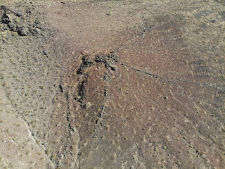
Fissure zone on SW side of higher topography. People for scale. Not sure the purpose of the excavation. LINK to jpg

Masked and socially distanced field work. LINK to jpg

Video overflight.

sUAS mapping

Along with the free flying overviews, I flew in mapping mode (using the PX4D mapper app) over most of the volcano taking 1778 images in mapping mode. I processed those in Agisoft Metashape to produce a colored point cloud, digital elevation model, and orthophoto. The latter two can be the basis of more mapping in ArcMap.

Tour of the data and its processing in Agisoft Metashape and ArcMap.

Map downloads

Hillshade overview. 600 dpi pdf download: LINK.

Ortho image overview. 600 dpi pdf download: LINK.

Hillshade of peak area. 600 dpi pdf download: LINK.

Ortho image of peak area. 600 dpi pdf download: LINK.

Map data downloads

  • 0.1 m/pix DEM and hillshade downloads (tif): LINK
  • 0.1 m/pix orthoimage download (tif): LINK

Topographic profile

The video presented above discusses the topographic profile cut from the DEM in ArcMap towards the end. This would be the basis for the geologic cross section, preferably without vertical exaggeration.

Topographic profile location. Bent along the path of our Saturday November 22, 2020 tour. LINK to png.

Topographic data text file: LINK and MATLAB script to plot it: LINK

No vertical exaggeration. Link to png.

Vertical exaggeration. LINK to png

2021 ADDENDUM:
For the October 2021 field work, we are trying to use STRABOSPOT for the digital mapping. I prepared a few items to help:

  • Simple tutorial. The students need to do all but the very last step (uploading after the field) BEFORE we go to the field: PDF
  • Video tutorial. I recorded all of this on the browser and the tablet with narration.

Tuesday, May 15, 2018

Specialization certificate for the assessment and management of geological and climate related risk (CERG-C) course in Geneva and Vulcano Island

I just returned from my second year of participation in the Specialization certificate for the assessment and management of geological and climate related risk (CERG-C) course in Geneva (Switzerland) and Vulcano Island (Sicily, Italy). It was stimulating, interesting, and beautiful. The course takes a "...multidisciplinary approach to the assessment and management of risk from natural hazards, merging ideas from disciplines such as the physical and social sciences, engineering, and economics" (website). The course has 8 modules and there were about 25 students from around the world participating. The course is lead by Professor Costanza Bonnadonna. Several other instructors participate and getting to know them has been quite nice. Amanda Clarke and I have joined the last few years

It is a tough place to work: view from La Fossa towards Vulcanello across the Vulcano town with Lipari and other Aeolian Islands behind

The last two years I have helped by providing a series of lectures in Geneva on topography and then participated in the field exercise on Vulcano Island (Sicily, Italy). I argue that it is a fundamental geophysical dataset for any hazard and risk assessment as it drives and resists processes and hazards. After all, potential energy = mass x gravity x relative height. Topography fits in the realm of Geodesy which is the science of accurately measuring and understanding three fundamental properties of the Earth: its geometric shape, its orientation in space, and its gravity field—as well as the changes of these properties with time. We know that surface processes act to change elevation through erosion and deposition while tectonic processes depress or elevate the surface directly. And, topography and geomorphology (study of landforms and surface processes) helps to link between timescales of seismology and crustal deformation (1-10 yr) and geology and tectonics (1-10 Myr)

Vulcano and topography and bathymetry of northern Sicily. Note that I demonstrate the very useful geomapapp.
I also demonstrate ArcGIS and show the data and topography from Vulcano.

At Vulcano, the students have the opportunity to put into practice their hazard and risk knowledge. The program starts with a field trip and lectures on the various volcanic hazards (unrest and degassing, single vulcanian, persistant vulcanian, subplinian from the main edifice ("La Fossa") and strombolian and lava flow eruptions from the adjacent "Vulcanello). Then the students work through vulnerability, warning messages, and even have a crisis exercise. They stay busy from 8 am to 10 pm. The studnet have to present almost every night a poster on what they analyzed for that day, with the assembled instructors as audience and evaluators. There are also evening lectures including a review of Italian earthquakes with extended lecture on L'Aquila by me and a very nice review of Italian Civil Protection by one of its representatives. And, one of the highlights is a volcano crisis "play" at the local elementary school in which the students have a script and take various roles as community members, media, safety staff, government officials, scientists, etc. to go throught a possible volcanic crisis at Vulcano. It was very cute and a great demosntration of how to engage communities to understand the hazards they face and what to do.

Professor Mauro Rosi from University of Pisa lecturing to the group with La Fossa vent behind.
Nice action video from the Mavic Air
INGV team demonstrating gas sampling from the fumaroles.

In order to demonstrate acquisition of topography as well as collect some for some of the research activities ongoing at Vulcano by the team, I worked with an INGV colleague Il maestro Dr. Fabio Pisciotta to collect photos from drones for structure from motion reconstructions. He has a lot of experience droning at Vulcano and was a great teacher. We teamed up with his Phantom 3 and our Phantom 4 Pro and collected more than 6000 images over the edifice. Stay tuned for the models...

Drone team.
Drone view of La Fossa.