Showing posts with label cinder cones. Show all posts

Wednesday, November 25, 2020

Warford Ranch volcano (Arizona) sUAS mapping

Introduction

We recently visited the Warford Ranch Volcano which is a low shield volcano that is part of the Sentinel-Arlington volcanic field of southwestern Arizona. It is about 3 million years old. It was a favorite field trip destination of Prof. Ronald Greeley. Shelby Cave worked on the Sentinel-Arlington field for her Ph.D. dissertation under the supervision of Prof. Greeley and after his passing she worked with Prof. Amanda Clarke.

Google maps location for Warford Ranch (NW of Gila Bend, AZ).

Professor Clarke is teaching the Advanced Field Geology course and she took the group to Warford Ranch volcano to examine its volcanology. I did some UAS-mapping to help with the documentation. This blog entry presents some of the products of the overflights with our Mavic Air and Phantom 4 Pro.

Oblique overviews

I flew the Mavic Air high to get some views over the volcano to assess its general form and the relation to adjacent landforms and geology.

View to the north. The cars are lower left are in our parking spot. LINK to jpg

View to the south-southwest. LINK to jpg

View to the south-southeast. LINK to jpg

Fissure zone on SW side of higher topography. People for scale. Not sure the purpose of the excavation. LINK to jpg

Masked and socially distanced field work. LINK to jpg

Video overflight.

sUAS mapping

Along with the free flying overviews, I flew in mapping mode (using the PX4D mapper app) over most of the volcano taking 1778 images in mapping mode. I processed those in Agisoft Metashape to produce a colored point cloud, digital elevation model, and orthophoto. The latter two can be the basis of more mapping in ArcMap.

Tour of the data and its processing in Agisoft Metashape and ArcMap.

Map downloads

Hillshade overview. 600 dpi pdf download: LINK.

Ortho image overview. 600 dpi pdf download: LINK.

Hillshade of peak area. 600 dpi pdf download: LINK.

Ortho image of peak area. 600 dpi pdf download: LINK.

Map data downloads

  • 0.1 m/pix DEM and hillshade downloads (tif): LINK
  • 0.1 m/pix orthoimage download (tif): LINK

Topographic profile

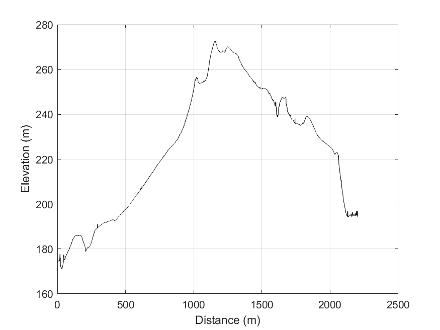
The video presented above discusses the topographic profile cut from the DEM in ArcMap towards the end. This would be the basis for the geologic cross section, preferably without vertical exaggeration.

Topographic profile location. Bent along the path of our Saturday November 22, 2020 tour. LINK to png.

Topographic data text file: LINK and MATLAB script to plot it: LINK

No vertical exaggeration. Link to png.

Vertical exaggeration. LINK to png

2021 ADDENDUM:
For the October 2021 field work, we are trying to use STRABOSPOT for the digital mapping. I prepared a few items to help:

  • Simple tutorial. The students need to do all but the very last step (uploading after the field) BEFORE we go to the field: PDF
  • Video tutorial. I recorded all of this on the browser and the tablet with narration.

Friday, May 5, 2017

Simple Topography Lectures at University of Geneva as part of CERG-C

I am visiting the University of Geneva as part of the CERG-C project. Professor Costanza Bonadonna is the leader of the activity which is a course on hazard and risk with an international group of students. They have been in Geneva for a few weeks for classroom work and starting tomorrow they go to Vulcano Island for practical experience. I am going to join.

I gave a lecture and a practical demonstration on the general topic of Topography, but trying to emphasize its fundamental value for science and applied value for hazard assessment. And, of course making the point that high resolution data are most useful.

Here are the pdfs to my lectures and demo:

Monday, May 26, 2014

Structure from Motion micro documentary from Merri Lisa Trigilio

Readers may know my current obsession with Structure from Motion (SfM). Here is a new 5 minute long documentary from Merri Lisa Trigilio on SfM. It is based on some work we have been doing on the volcanoes around the San Francisco volcanic field and the interaction between a possibly active fault and the 50-60ka SP lava flow.

Structure From Motion from Merri Lisa Trigilio on Vimeo.


Here are more SfM posts

Saturday, December 14, 2013

Exploring the Topographic Evolution of Cinder Cones

At the Fall AGU 2013, I presented a summary of work done by Emma Gleeman (Brown) and Sarah Zibart (Western Kentucky University) along with Amanda Clarke (ASU) and Fabrizio Alfano (ASU) as part of the Research Experience for Undergraduates: Landscape evolution in a monogenetic volcanic field led by Nancy Riggs at NAU and supported by the US National Science Foundation. Among other things, we used the 2D non linear diffusion code developed by Mattia de’ Michieli Vitturi (de’ Michieli Vitturi and Arrowsmith, Two-dimensional nonlinear diffusive numerical simulation of geomorphic modifications to cinder cones, Earth Surf. Process. Landforms (2013) and built on our good collaborations with Mattia.

Here is the presentation: pptx


Picture from the Autokite

Conclusions include:

  • Agglutinate is important in controlling cinder cone topographic development
    • Not extremely important for h/w ratios (age approximation)
    • Significant in controlling slope histogram
  • High resolution topography is required for good characterization of slope distributions, esp. for cones with agglutinated tops
  • 2D non-transport-limited linear diffusion and 1D production-limited linear diffusion models reasonably captured evolution of both agglutinated and non-agglutinated cones
  • Laboratory experiments agreed with histogram evolution predicted by numerical modeling for both agglutinated and non-agglutinated cones
  • Additional process rules (short range sheetwash, fluvial, and debris flow) of scoria and aeolian material is a next step