Showing posts with label Aerial photography. Show all posts

Sunday, December 13, 2020

New fast workstation and sUAS capability for School of Earth and Space Exploration course development

Overview

Our geoscience courses have benefited from plenty of course development, especially lately as we have moved online and virtual. I recently was able to invest SESE course fees to build out our capabilities for high resolution mapping and 3D work. Javier Colunga built a nice and fast Windows workstation, and we also purchased a Mavic Pro 2 sUAS system. The descriptions are below for reference.

Workstation description

We have been building these "gaming" style fast desktops for a while and this latest incarnation is powerful for graphics intensive and 3D work, especially structure from motion photogrammetry (e.g., Johnson, et al., 2014 and GSA short course).
Here is a short description of the hardware (cost approx. $5k):

  • CPU: Ryzen Threadripper 3970X 32-core/64-thread (with a premium cpu cooling solution)
  • Main Memory: 128GB DDR4 3600
  • Graphics Card: GeForce RTX 2080 Super
  • Storage: Samsung 1TB M.2 NVME OS drive, additional 4TB hard drive
  • Operating system: windows 10 Enterprise
  • Input: Logitech wireless keyboard and mouse
  • Monitor: HP 27 inch 1440P
Here is the main software installed:
  • Google Earth Pro
  • Matlab R2020a
  • Camtasia 2020
  • Cloudcompare
  • Agisoft Metashape
  • ArcGIS 10.7
  • QGIS
Here is more description, how to connect remotely, and a sign up sheet. LINK

sUAS description

For SESE, we have purchased a DJI Mavic 2 Pro (actually the FlyMore combo so it has a nice case and 3 batteries). This is a nice mapping and aerial documentation system.

Devin Keating has been helping to get the system into production mode. He has built a nice documentation of the system and its use. He also registered it with the FAA so we have a tail number. See this LINK. To operate it, one should have the part 107 Remote Pilot certification. And, there are ASU oversight requirements as well.

Recent course related work using this type of system (and computed on the nice workstation described above):


Warford Ranch volcano (Arizona) sUAS mapping

Virtual field geology exercises for GLG451 Field Geology I Spring 2020

Material for virtual exercises for GLG452 Field Geology II at Camp Tontozona AZ

Wednesday, November 25, 2020

Warford Ranch volcano (Arizona) sUAS mapping

Introduction

We recently visited the Warford Ranch Volcano which is a low shield volcano that is part of the Sentinel-Arlington volcanic field of southwestern Arizona. It is about 3 million years old. It was a favorite field trip destination of Prof. Ronald Greeley. Shelby Cave worked on the Sentinel-Arlington field for her Ph.D. dissertation under the supervision of Prof. Greeley and after his passing she worked with Prof. Amanda Clarke.

Google maps location for Warford Ranch (NW of Gila Bend, AZ).

Professor Clarke is teaching the Advanced Field Geology course and she took the group to Warford Ranch volcano to examine its volcanology. I did some UAS-mapping to help with the documentation. This blog entry presents some of the products of the overflights with our Mavic Air and Phantom 4 Pro.

Oblique overviews

I flew the Mavic Air high to get some views over the volcano to assess its general form and the relation to adjacent landforms and geology.

View to the north. The cars are lower left are in our parking spot. LINK to jpg

View to the south-southwest. LINK to jpg

View to the south-southeast. LINK to jpg

Fissure zone on SW side of higher topography. People for scale. Not sure the purpose of the excavation. LINK to jpg

Masked and socially distanced field work. LINK to jpg

Video overflight.

sUAS mapping

Along with the free flying overviews, I flew in mapping mode (using the PX4D mapper app) over most of the volcano taking 1778 images in mapping mode. I processed those in Agisoft Metashape to produce a colored point cloud, digital elevation model, and orthophoto. The latter two can be the basis of more mapping in ArcMap.

Tour of the data and its processing in Agisoft Metashape and ArcMap.

Map downloads

Hillshade overview. 600 dpi pdf download: LINK.

Ortho image overview. 600 dpi pdf download: LINK.

Hillshade of peak area. 600 dpi pdf download: LINK.

Ortho image of peak area. 600 dpi pdf download: LINK.

Map data downloads

  • 0.1 m/pix DEM and hillshade downloads (tif): LINK
  • 0.1 m/pix orthoimage download (tif): LINK

Topographic profile

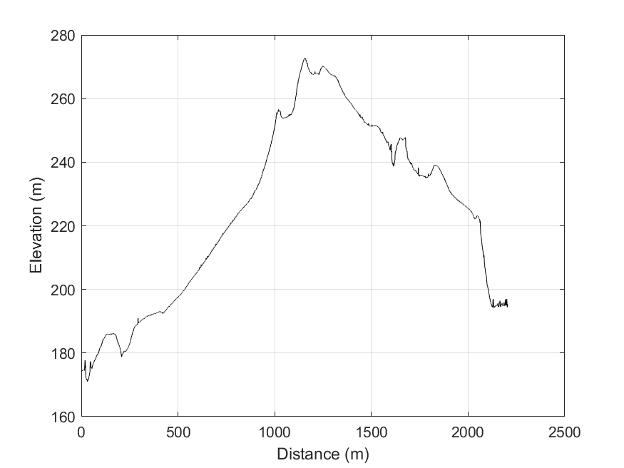
The video presented above discusses the topographic profile cut from the DEM in ArcMap towards the end. This would be the basis for the geologic cross section, preferably without vertical exaggeration.

Topographic profile location. Bent along the path of our Saturday November 22, 2020 tour. LINK to png.

Topographic data text file: LINK and MATLAB script to plot it: LINK

No vertical exaggeration. Link to png.

Vertical exaggeration. LINK to png

2021 ADDENDUM:
For the October 2021 field work, we are trying to use STRABOSPOT for the digital mapping. I prepared a few items to help:

  • Simple tutorial. The students need to do all but the very last step (uploading after the field) BEFORE we go to the field: PDF
  • Video tutorial. I recorded all of this on the browser and the tablet with narration.

Sunday, March 17, 2019

From crashing kites and Frankenmodels to efficient large-scale UAV acquisitions and beautiful shared 3D models (2018 GSA talk)

I was invited to give a presentation in a session at the Fall 2018 Geological Society of America session T60. Revolutions in Remote Sensing: Applications of UAVs to Field Mapping and Surface Analytics (organized by Dylan Blumentritt--Winona State University and Toby Dogwiler--Missouri State University). I decided to make a my presentation a bit of a reflection of how my own obsession with low altitude imaging had evolved and how far we had come. After all, I started in college working in the Fairchild Aerial Photography Collection when it was at Whittier College. So, I came up with a talk with the hopefully entertaining title of FROM CRASHING KITES AND FRANKENMODELS TO EFFICIENT LARGE-SCALE UAV ACQUISITIONS AND BEAUTIFUL SHARED 3D MODELS. I am putting links to the talks on line in case they might be useful: PPT and PDF.

The presentation shows a couple of maybe interesting things:

  1. It shows a pretty 3D point cloud (video above) from our Photogrammetric model of the Tecolote Volcano, Sonora, Mexico hosted at https://opentopography.org/.
  2. It spends some time talking about and making the case for the OpenTopography Community Dataspace.
  3. As part of the OpenTopography Community Dataspace discussion, I (with slides and ideas from Chris Crosby) talked about standardizing metadata for these long tail data. See for example the different styles of metadata documents ("Survey Report"): for example Almaty range front fault, Koram site or Clear Creek, Idaho post-fire debris flow erosion--note the ones I uploaded are not great examples :).
  4. Of course, one of the really nice things that the OpenTopography Community Dataspace publishing of one's data allows is to mint a DOI. That DOI allows then for a data citation. I have added a new part of my CV that has a section on data publication. Here is an example citation style:
    Arrowsmith, J R., DiMaggio, E. N., Garello, G. I., Villmoare, B. and LediGeraru Research Project (2018): Photogrammetric model of a portion of the LeeAdoyta Basin, Afar, Ethiopia (point cloud [122M points], orthophoto [2cm/pix], and DEM [25 cm/pix]). Distributed by OpenTopography. AccessedOctober 23, 2018. https://doi.org/10.5069/G95X271W.

The conclusions are useful to highlight as well:

  • We are part of a revolution in 3 and 4 D data collection and analysis
  • Additional needs for the community include
    • Optimized data acquisition strategies
    • Low cost and high performance computation of point clouds and models
    • Efficient and accurate georeferencing
    • High quality differencing for change detection
    • Bring the tools and data into the (outdoor) classroom; need more curriculum (c.f. GETSI - GEodesy Tools for Societal Issues (UNAVCO) at https://serc.carleton.edu/getsi/)
  • OpenTopography Community Dataspace
    • Great opportunity to expand the impact of emerging topography through improved access
    • Services and existing community of users
    • Community engagement & best practices
    • Please join us and start sharing your models and ideas for how to improve

Tuesday, December 20, 2016

Landers earthquake fault scarp Structure from motion

I made a movie of structure from motion high resolution view of 1992 Landers California earthquake fault scarp. Video starts with 2012 hillshade (Johnson, et al., 2014; available from OpenTopography here: link) in Google Earth to show location and then to a ground based set of photographs (see blue rectangles as focal planes) visualized in Agisoft Photoscan.

I am pretty pleased that the ground-based model worked so well. Now we can move forward with fine scale alignment with earlier topographic point clouds and compute differences over the 25 years since the earthquake--a project I have worked on with Dallas Rhodes for many years (see Arrowsmith and Rhodes, 1994 and also Haddad, et al., 2012).

See also these posts:

  • 2015 Anniversary of 1992 Landers California earthquake
  • SfM mapping--also has an orthophoto kmz of the Johnson, et al., 2014 data
  • Structure from Motion micro documentary from Merri Lisa Trigilio
  • References:

    • Arrowsmith, J. R., & Rhodes, D. D. (1994). Original forms and initial modifications of the Galway Lake Road scarp formed along the Emerson Fault during the 28 June 1992 Landers, California, earthquake. Bulletin - Seismological Society of America, 84.
    • Haddad, D. E., Akciz, S. O., Arrowsmith, J. R., Rhodes, D. D., Oldow, J. S., Zielke, O., … Shilpakar, P. (2012). Applications of airborne and terrestrial laser scanning to paleoseismology. Geosphere, 8(4). https://doi.org/10.1130/GES00701.1
    • Johnson, K., Nissen, E., Saripalli, S., Arrowsmith, J. R., McGarey, P., Scharer, K., … Blisniuk, K. (2014). Rapid mapping of ultrafine fault zone topography with structure from motion. Geosphere, 10(5). https://doi.org/10.1130/GES01017.1

    Thursday, December 20, 2012

    Structure from Motion mapping

    I have been fascinated with high resolution imaging for a while. This post accumulates a few files and links to present some recent activities.

    The main effort lately has been part of a collaboration with Sri Saripalli and Ed Nissen to use the tools of Structure from Motion to make high resolution digital elevation models and texture maps.

    We have been using AgiSoft to make topographic models from our uncontrolled aerial photography.

    Here is a powerpoint I presented at the 2012 SCEC meeting: ppt
    Here is a poster from Ed Nissen presented at the 2012 AGU meeting: pdf

    This video shows the result of a moderate resolution computation and then export of the texture map to KMZ:

    Here is a direct link to the video in mp4 format: link

    Dallas Rhodes and I played around with an AR Drone. It was pretty neat, but hard to fly as you can see in this video:

    Here is a direct link to the video in mp4 format: link

    Here are a couple of links that go along with our kit:
    Balloon and kite photography systems
    The Auto kite site in the research group of Professor Saripalli

    Saturday, November 12, 2011

    Updated pages for Kite and Balloon Aerial Photography

    Thanks to the hard work of Tsurue Sato, we have a newly updated set of pages for Kite and Balloon Aerial Photography.


    The new pages are connected from our Activetectonics research page: Low Altitude Aerial Photography.


    I have an old blog posting on this topic as well: Balloon Photography Update. Note that the videos there and on the new pages are some of the most popular of my youtube videos because they were embedded on the Arizona Balloon Company homepage...


    Here is a recent photo from CAMP SESE: