
The Mw7.3 Landers, California earthquake occurred on June 28, 1992 (USGS page). It is known for a number of interesting features including significant foreshocks and a complex multifault rupture. I was very much interested the surface rupture pattern and had the good fortune of responding quickly to the event with Dallas Rhodes as well as my fellow graduate students. To be there right after the event (in the rather hot summer Mojave Desert) was very exciting. We worked along the Emerson Fault (northern portion of the rupture).
Many colleagues studied the event and lots of cool and important papers were written. I won't summarize all here. I will link to a few and mostly emphasize our geomorphic studies of the rupture along the Emerson Fault.
The main summary paper put together shortly after the event is Sieh, et al., 1993.
A structural interpretation of the Emerson Fault deformation is in Aydin and Du, 1995.
The McGill and Rubin, JGR, 1999 paper is really cool with some pretty mapping, data synthesis and some cautions about interpreting single event offset data among other things. Here is a video panning along their rupture map:
Our detailed fracture mapping has not been published in detail. I summarize some of what we did logistically in this document about surveying (scroll to the end). Here is a compilation of the mapping (click to see bigger):

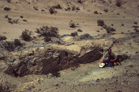
Dallas Rhodes and I were really interested in the potential to study the original forms and initial and ongoing modifications to the remarkable scarp that formed along the Emerson Fault. We set up a survey network and took many pictures along the rupture. We have revisited the site many times over the years to resurvey, describe, and photograph. A description of the initial changes was the first chapter of my dissertation and my first published paper as first author: Arrowsmith and Rhodes, Bulletin of Seismological Society of America, 1992. Here is a link to a series of annotated photographs in which I wondered if there were multiple senses of motion along the fault surface. Here are some kite photos of the site in 1998. In 2008, we laserscanned the site. Those data are also among the Terrestrial Laser Scanner data on OpenTopography. And, in 2012, we flew some cameras from a balloon over the site and were able to produce some nice 3D models:
I put together a powerpoint on some of the fault scarp work on the Emerson Fault here (video link to lecture) as part of a series of active tectonics lectures. The Haddad et al. 2012 Geosphere paper presents some of the updated work at the site. More to do!
No comments:
Post a Comment
Note: Only a member of this blog may post a comment.