Monday, December 27, 2021

Eminent earthquake scientists: Clarence Allen and Robert Wallace oral histories

For some "light reading" over the winter break, I have enjoyed a read of oral histories of Clarence Allen (Caltech) and Robert Wallace (USGS).
EARTHQUAKES, MINERALS AND ME: WITH THE USGS, 1942-1995 by Robert E. Wallace; Oral History Interviews With Stanley Scott; USGS Open-File Report 96-260

Connections EERI Oal History Series: Clarence Allen with interviewer Stanley Scott
CLARENCE R. ALLEN (1925-2021) INTERVIEWED BY DAVID A. VALONE Caltech archives. This latter one has a bit more about Caltech and is slightly less polished than the first.

Maybe I at times too sentimental, but I found these personal and scientific histories throught provoking and inspiring, not only for their tellings of important steps in the history of earthquake science and service, but also for their modest, laconic, and matter of fact story telling. I am also fortunate to have substantial memories of interacting with both of them personally and also of the transition at the end of their careers and the beginning of mine (I entered graduate school at Stanford University in Fall 1989). I also appreciate the effort of EERI to accumulate those and other oral histories.

One thing that comes to mind is that it would be nice to include some histories from women who have contributed in these areas. I will work on that for a future blog post.

Bob Wallace was inspiring as an earthquake geologist. I followed some of his work quite closely as I shared an obsession with geomorphic indicators of faulting, although certainly with less of an impact...
Just a couple of examples from his papers:

  1. 1949 - Wallace, R. E., Structure of a portion of the San Andreas rift in southern California: Bulletin of the Geological Society of America, v. 60, n. 4, p. 781-806.. This is cited as one of the earliest focused mapping efforts along the San Andreas Fault. He mapped substantial offset along the San Andreas Fault and also worried about the fault zone core and interactions of the drainage network with the fault zone. At one point, I colored the detailed map to appreciate it better.
  2. 1968 - Wallace, R. E., Notes on stream channels offset by the San Andreas fault, southern Coast Ranges, California, in Dickinson, W. R., and Grantz, Arthur, eds., Proceedings of conference on geologic problems of San Andreas fault system: Stanford University Publications in Geological Science, v. 11, p. 6-21.. This was a landmark in my mind as he noted offsets along the San Andreas Fault in the Carrizo Plain as indicators of short and longer term indicators of recurrent fault slip. It was in a somewhat difficult to find publication. But, being around Stanford University (and having to move out of the Geology Corner after the Loma Prieta Earthquake), there were numerous copies to be found. Figures 6 and 7 of the histograms of numbers of channels with certain offset sizes was something we followed up on a fair bit.
  3. 1990 - Wallace, R. E., (editor) The San Andreas Fault System, California: U. S. Geological Survey Prof. Paper 1515, 283 p.. This was his magnum opus. I was lucky once to meet him in his office at USGS Menlo Park and he asked if I had a copy yet. I did not even though I had stared at it. He reached into his filing cabinet and gave me his copy! I should have asked him to sign it or something but I certainly treasure that copy. It has now been rebuilt a few times...
  4. 1992 - Wallace, R. E., Ground-squirrel mounds and patterned ground along the San Andreas fault in central California: U. S. Geological Survey, Open-file report n.91-149, p. 1-21.. This was a modest contribution, but I had a couple of conversations with him about it as we shared our enthusiasm for the Carrizo Plain. In his related GSA presentation, he even mentioned me as someone who might pick it up! Scared the crap out of me. We never really did a systematic effort on this but it remains a fascinating problem. I talk about it with people every time I get to the Carrizo Plain.
THere is a lot more to say and remember about Bob Wallace. My memories of him are also tied to Kerry Sieh who worked with Bob and honored him by naming the offset channel he explored in the 1968 paper "Wallace Creek". How many times have I read the Sieh and Jahns 1984 paper: Sieh, K. E., and Jahns, R. H. (1984). Holocene activity of the San Andreas fault at Wallace Creek, California. Geological Society of America Bulletin, 95, 883–896.. We even revisited this in our 2019 paper.

One of my San ANdreas Fault tour videos over the Carrizo Plain. Hillshades produced by me from the B4 project at OpenTopography.

I did not interact with Clarence Allen as much as I did with Bob Wallace, but I did have a few nice conversations with him. I think he was more serious in the conversations than I was. They main ones were when I was thinking about going to Caltech to work with Kerry Sieh. Clarence and I talked about science, but also about trout fishing. I regret never taking him up on an invite to fish in the San Bernardino Mountains. I think my father had fished some of the same places there around and below Lake Arrowhead or Big Bear Lake.
Two papers among many I would like to highlight from Clarence:

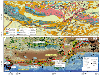
  1. Allen, C. R. (1968). The tectonic environments of seismically active and inactive areas along the San Andreas fault system. Proceedings of Conference of Geologic Problems of San Andreas Fault System, 5(1496), 70–80.. This stands as an important first order characterization of the San Andreas Fault system and the recognition that the geology was an important control on the current behavior of the system. I have used Figure 1 here and there over the years when I kick of talks on the San Andreas Fault.
  2. Geological Criteria for Evaluating Seismicity: Address as Retiring President of The Geological Society of America, Miami Beach, Florida, November 1974 CLARENCE R. ALLEN GSA Bulletin (1975) 86 (8): 1041–1057. This is a classic that helps to introduce the concepts of earthquake geology and the value of the geologic record in the study of recently active faults.
My recent attempt to follow Prof. Allen's ideas about the San Andreas Fault (some edits on the caption from Mike Oskin; we made this as a prototype for a SCEC request). The geology of the plate boundary shows the SAFS progressively dismembering the former subduction system (as indicated by the paired Mesozoic metamorphic--green and granitic--red rocks) (https://ngmdb.usgs.gov/gmna/; upper panel). This framework is a first order control on the behavior of the system (lower panel): active faults (USGS and CGS 2021) and M>4 seismicity (https://earthquake.usgs.gov/earthquakes/search/) overlain on the GMRT (Ryan, et al., 2009).

Sunday, December 5, 2021

AI art: what does " Tectonic Geomorphic San Andreas Fault" look like?

I saw a link to https://app.wombo.art/ on twitter and people were posting what they got out of using their research or dissertation titles as a prompt. It is pretty amazing.

I gave it a try. My dissertation was entitled "Coupled Tectonic Deformation and Geomorphic Degradation along the San Andreas Fault System". I tried that as well as a shorter version "Tectonic Geomorphic San Andreas Fault" with a couple of different styles. I have to ponder the results. Some of the other examples work well when there is an object more recognizeable (such as a bird or T-cell), or somehow I need to give it a more interesting prompt. But the results are interesting. I like the trading card format.

Later on, I saw something about how the company could sell the "art" as NFTs but I guess I am not too worried about it.

Wednesday, December 1, 2021

Remembering Paul J. Umhoefer

I recently wrote this memorial for the Geological Society of America Structural Geology and Tectonics Division (which I am now beginning my stint as chairman or soon will). That is the reason for the first person plural.

We heard with great sadness and shock of the passing of our dear friend and colleague Professor Paul J. Umhoefer (Northern Arizona University) in late November 2021. Some of us saw him at the 2021 GSA meeting and to lose him so soon after weighs on us.

Paul Umhoefer was a great scientist, mentor and teacher, and servant to his professional community and department. He was well known for his research in tectonics, basin analysis, structural geology with carefully collected field data from the western US, Baja California, and Anatolia.

Much of his research was done in close collaboration with his many students at NAU. He was a strong mentor who guided many of those projects to publication and the students went on to success, especially in academia and the petroleum and geo-environmental industries. His professional colleagues appreciated his guidance and invitation to join interesting projects.

Paul was a tireless leader in the geoscience community. He helped to propel important community initiatives, including Margins/GeoPrisms. He not only contributed synthetic ideas but was an integrator and conciliator. He was an effective chair of his department helping guide it in a time of important growth. We are grateful for this leadership in the Geological Society of America Structural Geology and Tectonics Division where he was a long time active member, proponent of GSA fellows, and had recently completed the arc of leadership of the division.

Along with his tireless work ethic, Paul was enthusiastic and gregarious with a big smile and a joke for his friends and colleagues delivered in his deep creaky voice. He loved to talk about ideas: geoscience, politics, sports.

We counted on seeing him again soon. We are sorry to lose him and our thoughts are with his family and close friends.

Paul Umhoefer in one of his favorite places: the southern Baja California coast line with uplifted terraces and Tertiary sedimentary and volcanic rocks awaiting his attention (Arrowsmith photo, 2005)

--Ramon Arrowsmith (incoming Division Chair) on behalf of the Geological Society of America Structural Geology and Tectonics Division

Sunday, October 24, 2021

Remembering Omar Abdullah

I heard in late August 2021 that Omar Abdullah was killed in the unrest that is occurring in Ethiopia. I did not learn of any details but he was an embasa--a lion--and no doubt he was there defending his family and lands. He was an amazing guy that I got to know over the years working in the Afar with the Ledi Geraru Project. Others knew him better. I appreciated him very much. He was from the Hadar woreda--administrative area--but we gave him a special title: "camp specialist" so we could keep him employed even when we were working in other areas with other Afars. Even the other Afars grew to appreciate him and his sense of humor.

Here are two pictures from 2002 (along with Mark Jakofsky). We can appreciate Omar's sense of fashion and poise.

Omar had a great sense of humor. There is a drainage called "Fat Ha'". It means big mouth in Afar. As Omar said, "like me!" He was also fascinated with our western scientist lives. He called himself "Black American." He was very friendly and happy to solve problems for the success of the project.

2006 pictures including Erin DiMaggio--she and I had lots of fun with Omar over the years!

We probably will not be back to Ethiopia and the Afar for a while sadly given the unrest. It will be very sad when we do and we really feel the loss of Omar (and probably others of our Afar friends). May he rest in peace. He always wanted me to bring him a small radio I think so he could listen to music while he waited for us to our work. I regret never quite getting around to that.

2009 and 2012 pictures including Erin DiMaggio and Matt Jungers.

Friday, June 11, 2021

NSF AC GEO Report on Portfolio Review of EAR Seismology and Geodesy Instrumentation Completed

In April 2021, we finished a fairly intensive project: AC GEO Report on Portfolio Review of EAR Seismology and Geodesy Instrumentation. I defer to that page as the official one, but I wanted to put a note here as well.

I was the chair of the committee, and the citation is

Arrowsmith, J R., Brodsky, E. E., Cooper, C. M., Elliott, J. L., Fee, D., Fischer, K.M., Hammond, W. C., La Femina, P., Lekic, V., Wang, H., and Worthington, L. L., Recommendations for Enabling Earth Science Through NSF’s Geophysical Facility – A Portfolio Review of EAR Seismology and Geodesy Instrumentation, Report to the US National Science Foundation, April 2021.

But, I want to really highlight the efforts of the entire committee! This was a really strong group that worked hard and respectfully together to come up with something we are quite proud of. It has some depth which I hope will give it shelf life.

Here are the rest of the Acknowledgements:
Thank you to UNAVCO President Rebecca Bendick and Director of Geodetic Infrastructure Glen Mattioli as well as IRIS President Robert Woodward and Portable Programs Manager Kent Anderson for their rapid and thorough responses to the committee queries. Christopher Crosby (UNAVCO) provided input on geodetic imaging. Jonathan Ajo-Franklin (Rice University), Kent Anderson (IRIS), Jnaneshwar Das (Arizona State University), Rob Evans (WHOI), W. Steven Holbrook (Virginia Tech), and Glen S. Mattioli (UNAVCO) kindly made themselves available for interviews with the committee. We are grateful to Lindsay M. Martin who supported the committee very ably as science assistant from the National Science Foundation. Finally, many thanks to Margaret Benoit (National Science Foundation Program Director) for her careful guidance.

Wednesday, January 6, 2021

Salt River terraces field geology exercise and updated guide

The Salt River in central Arizona has a spectactular set of fluvial terraces developed along it. I have lead a number of field trips along the Salt River for outreach and most importantly for our GLG451 Field Geology I course where we use a site along the Salt River for a mapping exercise. I have recently updated the materials associated with that exercise in anticipation of this Spring's class which will include a virtual component.

Tour from ASU to the Salt River site.
Drone overflight of the key sites for the exercise.

I built on some of the very nice writing and descriptions of Professor Pewe when I wrote up a field trip guide and ran a few field trips in the early 2000s. See this LINK. I updated that guide and it is available here: Landscape and geologic history along the Salt River near Tempe and Mesa, Arizona. I updated this document February 14, 2022.

Here is the assignment with many additional links and explanations: Virtual Field Geology assignment for Salt River Field Geology I 2021.
I made a long explanation of the GIS:

These were of great interest to Professor Troy L. Pewe of Arizona State University's Department of Geology. He moved to Arizona from Alaska and converted his research from permafrost to desert processes. I was lucky to learn from him when I first came to ASU in 1995. He took me under his wing and shared with me much of what he had learned. Most importantly, he helped me to learn the field trips and field sites he had developed and discovered. I am extremely grateful to him. I recognize Brian Gootee who was a great friend of the Pewe Family and who has preserved much of the Pewe legacy at the Arizona Geological Survey.


Pictures from those early field trips with Prof. Pewe.