Showing posts with label San Andreas Fault. Show all posts

Friday, March 8, 2024

Remembering Thomas C. Hanks

I attended the Tom Hanks, a Remembrance symposium at the USGS in Moffett Field Oct. 17, 2024. It was a great chance to remember Tom, reflect on his vast scientific and personal impacts, and to catch up with old friends and colleagues. It was also nice to meet Tom's daughters. I was fortunate to be able to make a presentation. Here is my talk: LINK.

Here is the program from the event: LINK

~~~~~~~~~~~~~~~~~~~~~~~~~~~~~~~~~~~~~~~~~

I heard that Thomas C. Hanks passed away recently. He was a mentor to me. He worked for his career with the US Geological Survey. The memorials of him from his colleagues will be many and deep. I wanted to capture some of my memories of him. Tom was very supportive of young scientists and very broad in his scientific thinking. While he was most well known as a seismologist, his work in geomorphology and fault scarps and fragile geologic features was transformative.


This was a sticky on a manuscript draft he once gave me after a discussion on uncertainties in morphologic datting. Look at the nice handwriting (usually from a well sharpened #2 pencil). And the signature THanks.

Tom was on my Ph.D. supervisory committee. I was at Stanford and Tom was in Menlo Park at the USGS. Like many of his colleagues there, he was very generous with his time with the Stanford students. We talked a lot about fault scarps and diffusion, but also about the San Andreas Fault and I was able to drive for him on a few field trips to the SAF in the southern Bay Area into the Creeping Section. With Professor Gordon Brown's support (chair of our department at the time), Tom helped to lead an active tectonics seminar one quarter.

Tom's work on the age of scarplike landforms from diffusion-equation analysis (title of one of his latter papers on the subject) was very influential. He teamed up with Robert Wallace and others to take something simple about how fault scarps apparently change shape over time and quantify it in a realistic way. There are numerous important papers on the topic with Tom as an author but two seminal ones are:
Hanks, T. C., Bucknam, R. C., Lajoie, K. R., & Wallace, R. E. (1984). Modification of wave-cut and faulting-controlled landforms. Journal of Geophysical Research. https://doi.org/10.1029/JB089iB07p05771
and
Hanks, T. C. (2000). The Age of Scarplike Landforms From Diffusion-Equation Analysis. https://doi.org/10.1029/rf004p0313 in Quaternary Geochronology: Methods and Applications. In AGU Reference Shelf 4 (Vol. 4).

Among many other contributions on the age of scarplike landforms, Tom introduced a simple morphological dating approach: reduced slope-offset. He argued for a measure of the scarp midpoint slope (reduced by the far field slope) versus the vertical offset and he developed a nice calibration along with his colleagues for the rate constant k. He favored analytical solutions (tolerating my numerical approach).
One small anecdote that I always appreciated on the geomorphology side was his desire to name a unit for GK Gilbert (1m2/kyr = 1GKG). See the seminal 1984 Hanks et al JGR paper. It did not catch on but was a fun idea.

In 2007, David Haddad and I went with Tom to Northern Arizona University to see the collection of his father's photographs that he had endowed: Repeat Photography Site for The James J. Hanks Photographs, 1927-1928. Tom, like always, was deeply engaged/obsessed with the topic at hand. He worked hard to relocate and repeat his father's photographs, as well as to tell their story.

Whilst on the trip to Flagstaff, Tom, David, and I stopped to see and discuss the Granite Dells (near Prescott, AZ). Tom had been leading parts of the seismic hazard analysis for the Yucca Mountain possible nuclear repository. The problem they were coming up with was the age of the landscape was great (million year old landforms) and there were fragile geologic features and precarious rocks that may have been there fragile for a large fraction of that time. However, the extrapolation of the ground motion predictions would be to extreme, possibly unrealistic levels. Tom was interested in these million-year-old landscapes of fragile geologic features and recognized their value as an observational constraint for seismic hazard analysis. This is an impressive product of their work:
Hanks, T. C., Abrahamson, N. A., Baker, J. W., Boore, D. M., Board, M., Brune, J. N., Cornell, C. A., & Whitney, J. W. (2012). Extreme Ground Motions And Yucca Mountain. Extreme Ground Motions and Yucca Mountain Open-File Report 2013–1245, US Geological Survey.

Tom was interested in precariously balanced rocks given their use as a part of seismic hazard analysis. He thought it might be helpful for new people to get involved. So, he pulled David and I into it. He was supportive and helped generate some funds for us. That lead to a couple of nice papers lead by David. I regret that we did not have Tom as a coauthor:
Haddad, D. E., Akciz, S. O., Arrowsmith, J. R., Rhodes, D. D., Oldow, J. S., Zielke, O., Toke, N. A., Haddad, A. G., Mauer, J., & Shilpakar, P. (2012). Applications of airborne and terrestrial laser scanning to paleoseismology. Geosphere, 8(4). https://doi.org/10.1130/GES00701.1
Haddad, D. E., Zielke, O., Arrowsmith, J. R., Purvance, M. D., Haddad, A. G., & Landgraf, A. (2012). Estimating two-dimensional static stabilities and geomorphic settings of precariously balanced rocks from unconstrained digital photographs. Geosphere, 8(5). https://doi.org/10.1130/GES00788.1

A final lesson from Tom is that senior scientists should be generous and use their privilege to do good. Tom was a widely appreciated mentor of younger scientists--men and women. He was also a leader who did not shy away from trying to do the right thing. Just one example relates to another senior scientist who recently passed away: Paul Tapponier. Professor Tapponier led a transformation of our understanding of continental tectonics. He favored results with relatively high slip rates and thus the inference that the deformation even in plate interiors was more plate-like. Tom supported his colleague Wayne Thatcher who had come up with a result based on geodesy for the deformation of the Asian continental interior (Thatcher W. 2007. Microplate model for the present-day deformation of Tibet. J. Geophys. Res. 112:B01401) (and that did not sit well with Paul). Zack Washburn and I had written a paper based on paleoseismology in which we could not support enough earthquakes to support a high slip rate). Tom stepped in to mediate between Wayne and Paul and consulted me as part of his preparations. Tom had the stature, the intelligence, maturity and deserved respect so that he was able to set the tone for what I gather was a productive meeting.

I ended up with a copy of Tom's USGS bio and I note the following which is a nice example of his writing and matter-of-fact approach:

Monday, December 27, 2021

Eminent earthquake scientists: Clarence Allen and Robert Wallace oral histories

For some "light reading" over the winter break, I have enjoyed a read of oral histories of Clarence Allen (Caltech) and Robert Wallace (USGS).
EARTHQUAKES, MINERALS AND ME: WITH THE USGS, 1942-1995 by Robert E. Wallace; Oral History Interviews With Stanley Scott; USGS Open-File Report 96-260

Connections EERI Oal History Series: Clarence Allen with interviewer Stanley Scott
CLARENCE R. ALLEN (1925-2021) INTERVIEWED BY DAVID A. VALONE Caltech archives. This latter one has a bit more about Caltech and is slightly less polished than the first.

Maybe I at times too sentimental, but I found these personal and scientific histories throught provoking and inspiring, not only for their tellings of important steps in the history of earthquake science and service, but also for their modest, laconic, and matter of fact story telling. I am also fortunate to have substantial memories of interacting with both of them personally and also of the transition at the end of their careers and the beginning of mine (I entered graduate school at Stanford University in Fall 1989). I also appreciate the effort of EERI to accumulate those and other oral histories.

One thing that comes to mind is that it would be nice to include some histories from women who have contributed in these areas. I will work on that for a future blog post.

Bob Wallace was inspiring as an earthquake geologist. I followed some of his work quite closely as I shared an obsession with geomorphic indicators of faulting, although certainly with less of an impact...
Just a couple of examples from his papers:

  1. 1949 - Wallace, R. E., Structure of a portion of the San Andreas rift in southern California: Bulletin of the Geological Society of America, v. 60, n. 4, p. 781-806.. This is cited as one of the earliest focused mapping efforts along the San Andreas Fault. He mapped substantial offset along the San Andreas Fault and also worried about the fault zone core and interactions of the drainage network with the fault zone. At one point, I colored the detailed map to appreciate it better.
  2. 1968 - Wallace, R. E., Notes on stream channels offset by the San Andreas fault, southern Coast Ranges, California, in Dickinson, W. R., and Grantz, Arthur, eds., Proceedings of conference on geologic problems of San Andreas fault system: Stanford University Publications in Geological Science, v. 11, p. 6-21.. This was a landmark in my mind as he noted offsets along the San Andreas Fault in the Carrizo Plain as indicators of short and longer term indicators of recurrent fault slip. It was in a somewhat difficult to find publication. But, being around Stanford University (and having to move out of the Geology Corner after the Loma Prieta Earthquake), there were numerous copies to be found. Figures 6 and 7 of the histograms of numbers of channels with certain offset sizes was something we followed up on a fair bit.
  3. 1990 - Wallace, R. E., (editor) The San Andreas Fault System, California: U. S. Geological Survey Prof. Paper 1515, 283 p.. This was his magnum opus. I was lucky once to meet him in his office at USGS Menlo Park and he asked if I had a copy yet. I did not even though I had stared at it. He reached into his filing cabinet and gave me his copy! I should have asked him to sign it or something but I certainly treasure that copy. It has now been rebuilt a few times...
  4. 1992 - Wallace, R. E., Ground-squirrel mounds and patterned ground along the San Andreas fault in central California: U. S. Geological Survey, Open-file report n.91-149, p. 1-21.. This was a modest contribution, but I had a couple of conversations with him about it as we shared our enthusiasm for the Carrizo Plain. In his related GSA presentation, he even mentioned me as someone who might pick it up! Scared the crap out of me. We never really did a systematic effort on this but it remains a fascinating problem. I talk about it with people every time I get to the Carrizo Plain.
THere is a lot more to say and remember about Bob Wallace. My memories of him are also tied to Kerry Sieh who worked with Bob and honored him by naming the offset channel he explored in the 1968 paper "Wallace Creek". How many times have I read the Sieh and Jahns 1984 paper: Sieh, K. E., and Jahns, R. H. (1984). Holocene activity of the San Andreas fault at Wallace Creek, California. Geological Society of America Bulletin, 95, 883–896.. We even revisited this in our 2019 paper.

One of my San ANdreas Fault tour videos over the Carrizo Plain. Hillshades produced by me from the B4 project at OpenTopography.

I did not interact with Clarence Allen as much as I did with Bob Wallace, but I did have a few nice conversations with him. I think he was more serious in the conversations than I was. They main ones were when I was thinking about going to Caltech to work with Kerry Sieh. Clarence and I talked about science, but also about trout fishing. I regret never taking him up on an invite to fish in the San Bernardino Mountains. I think my father had fished some of the same places there around and below Lake Arrowhead or Big Bear Lake.
Two papers among many I would like to highlight from Clarence:

  1. Allen, C. R. (1968). The tectonic environments of seismically active and inactive areas along the San Andreas fault system. Proceedings of Conference of Geologic Problems of San Andreas Fault System, 5(1496), 70–80.. This stands as an important first order characterization of the San Andreas Fault system and the recognition that the geology was an important control on the current behavior of the system. I have used Figure 1 here and there over the years when I kick of talks on the San Andreas Fault.
  2. Geological Criteria for Evaluating Seismicity: Address as Retiring President of The Geological Society of America, Miami Beach, Florida, November 1974 CLARENCE R. ALLEN GSA Bulletin (1975) 86 (8): 1041–1057. This is a classic that helps to introduce the concepts of earthquake geology and the value of the geologic record in the study of recently active faults.
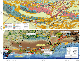
My recent attempt to follow Prof. Allen's ideas about the San Andreas Fault (some edits on the caption from Mike Oskin; we made this as a prototype for a SCEC request). The geology of the plate boundary shows the SAFS progressively dismembering the former subduction system (as indicated by the paired Mesozoic metamorphic--green and granitic--red rocks) (https://ngmdb.usgs.gov/gmna/; upper panel). This framework is a first order control on the behavior of the system (lower panel): active faults (USGS and CGS 2021) and M>4 seismicity (https://earthquake.usgs.gov/earthquakes/search/) overlain on the GMRT (Ryan, et al., 2009).

Sunday, December 5, 2021

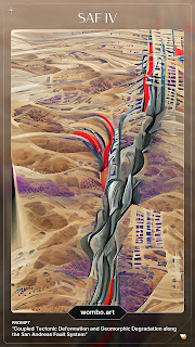
AI art: what does " Tectonic Geomorphic San Andreas Fault" look like?

I saw a link to https://app.wombo.art/ on twitter and people were posting what they got out of using their research or dissertation titles as a prompt. It is pretty amazing.

I gave it a try. My dissertation was entitled "Coupled Tectonic Deformation and Geomorphic Degradation along the San Andreas Fault System". I tried that as well as a shorter version "Tectonic Geomorphic San Andreas Fault" with a couple of different styles. I have to ponder the results. Some of the other examples work well when there is an object more recognizeable (such as a bird or T-cell), or somehow I need to give it a more interesting prompt. But the results are interesting. I like the trading card format.

Later on, I saw something about how the company could sell the "art" as NFTs but I guess I am not too worried about it.

Friday, March 8, 2019

Idea for an earthquake intensity exercise based on 1857 Ft. Tejon earthquake data

I was cleaning some files yesterday and I found an old exercise I had deployed when I was first teaching Introductory Geology. It was intended to help students understand earthquake intensity (vs.) magnitude. I took the felt intensities as reported by D. C. Agnew and K. Sieh (1978), A documentary study of the felt effects of the great California earthquake of 1857, Bull. Seismol. Soc. Amer., vol. 68, pp 1717-1729 and compiled some of the more easily interpreted ones into a table and then provided a simple map of California for the students to map the intensities. Here is a link to the compiled data from Agnew and Sieh. THe work of Kerry Sieh on the 1857 earthquake is seminal. I think it was an ok exercise, but there are probably more interesting and more recent datasets. For example, I like the twitter-based work that is coming from the USGS colleagues. It should be possible to take some sample tweets and do an intensity mapping.

The 1857 earthquake and its foreshocks and aftershocks are fascinating an a sobering reminder of what will happen one day in California.

This figure from Toké and Arrowsmith, 2006 shows the 1857 foreshocks and the mainshock distribution (the latter is what the exercise mentioned in the last paragraph is supposed to look like) and compares it with the historic Parkfield earthquakes.

Monday, June 5, 2017

Some new San Andreas Fault tour videos of 1 m bare earth hillshades

I have been preparing a lecture and I built some new simple videos flying along the San Andreas Fault. The videos are made by me flying along in Google Earth with 1 m hillshades produced from lidar topography data collected along the San Andreas Fault. The videos are on youtube in this play list: https://www.youtube.com/playlist?list=PLFfZSFyNZ_jZm86F1TsnYfuuYNef_Uh21. I also put the MP4s in this folder--they are numbered 1-8 from NW-SE.

The flights follow generally along the San Andreas Fault from Point Arena to the southern Carrizo Plain (Dragon's Back and Northern Elkhorn Hills):

The data were processed at www.opentopography.org and come from 3 really cool datasets:

Thursday, March 16, 2017

Mapping landforms with applications to geomorphology and earthquake geology EXERCISE

I wanted to share a project I have developed on and off for about 10 years. It is a classroom exercise for Mapping landforms with applications to geomorphology and earthquake geology. So far, it has an example for strike-slip faults (Wallace Creek along the San Andreas Fault), and blind thrust faults (Wheeler Ridge in Southern California). I have an intention to add a normal fault example but have not finished it yet.

The basic idea is that the exercises could be done "analog"--that is on paper in a classroom. They emphasize some simple morphologic and geomorphic mapping (but on high resolution topography base maps from lidar data collected by NCALM and available for download from OpenTopography), and then provide landform ages so that students can calculate slip rate or surface uplift rates. I am not sure they are so well explained so any feed back is welcome.

Exercise material:

Sunday, January 31, 2016

Short Course just completed: Imaging and Analyzing Southern California's Active Faults with High Resolution Topography

We just completed our most recent OpenTopography short course: Imaging and Analyzing Southern California's Active Faults with High Resolution Topography. The course was sponsored by The Southern California Earthquake Center, UNAVCO, EarthScope, and OpenTopography. It was a pleasure to work again Chris Crosby and Ed Nissen and many thanks to Alana Williams (along with Jessica Sutton, Barrett Salisbury, and Gayatri Marliyani) for the local logistical support.

Nice montage put together by Barrett Salisbury for the course advertisement.

We had 90 applications for just 34 slots, so we emphasized early career scientists (mostly graduate students), and research in Southern California given SCEC's sponsorship. We hope to run another course soon (April 2016?) to catch up a bit more with the demand. It was wonderful to meet new people and share our enthusiasm for high resolution topography!

Students hard at work in the computer lab--Ed Nissen at the controls.

New: We recorded some of the talks. I made a summary playlist of my talk as a test. The audio is not great, but it is a summary motivation for the meeting: Sharpening our view of earth processes with high resolution topography

Summary write up for EarthScope newsletter but of relevance here too:

High resolution topographic data has become an important tool for earthquake scientists to make detailed observations and model surface evolution. Within the last decade, several efforts have been made to collect high resolution topographic (HRT) data for active faults (e.g. The B4 project, EarthScope, and numerous National Center for Airborne Laser Mapping--NCALM and USGS projects). These datasets are freely available online through OpenTopography, a NSF funded data distribution portal. The active faulting community has taken great interest in these exciting datasets, using them to generate new and important insights into earthquake processes in Southern California and elsewhere.

The EarthScope program supported the acquisition of several thousand square km of high resolution topography from lidar along active faults of the western US. The target areas included Northern, Southern & Eastern California (everything not already covered by the B4 project along the San Jacinto fault and southern San Andreas Fault; Prentice, et al., 2009), Yakima (Washington), Alaska (portions of the Denali rupture and Totschunda fault--see figure), and the Intermountain Seismic Belt (portions of the Wasatch Fault and Yellowstone). These data have been invaluable for studying deformation processes in a complementary mode to the fault zone drilling, geodetic, and seismological observatories of EarthScope.

Reference:
Prentice, C. S., Crosby, C. J., Whitehill, C. S., Arrowsmith, J R., Furlong, K. P., Phillips, D. A., GeoEarthScope LiDAR illuminates northern California's active faults, EOS Transactions of the American Geophysical Union, v. 90, no. 7, p. 55, 2009.

Saturday, November 15, 2014

SoSAFE and Earthquake Geology Geochronology workshop report (Southern California Earthquake Center)

Kate Scharer (USGS), Mike Oskin (UC Davis) and I organized a geochronology workshop for the Southern California Earthquake Center community this fall. We emphasized methodologies useful for investigating fault slip behavior over time scales from 102 to 106 years. That included Terrestrial Cosmogenic Nuclides, Uranium Series, and Optically Stimulated Luminescence. We did not talk so much about 14C given its relative maturity, but we certainly recognize its continued value.

Kate lead the charge on the completion of the workshop report. It has a nice summary of the topics covered (here is the original agenda). I had a sense of a real acceleration in the number and quality of applications of the methods and the resulting rich depiction of deformation rates and their variations across time and space in Southern California. I was particularly moved by the climate modulation on the development of landforms (alluvial fans, channels, etc.) that serve as markers as well as the possible temporal coherence of wet and dry times across the region. I think that this modulation and coherence can be exploited with more intensive application of geochronology.

I learned a lot more geochronology, especially having just been at the EarthScope Geochronology Institute a week or so earlier--note that the talks and some of the videos are up (where we covered some similar topics and where Kate was a speaker on 14C). It was very nice to see many SCEC friends and colleagues.

Friday, September 12, 2014

Southern California Earthquake Center 2014 meeting group picture

Many of my students and colleagues and I just returned from the 2014 Southern California Earthquake Center meeting. It was really great: so much energy, so many old and new friends and colleagues. It is a very strong community with a world-leading emphasis on earthquake system science. I am on the Planning Committee and was very engaged many aspects of the meeting.

Here is a fun picture from the meeting:

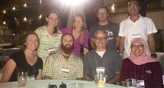
Back row: Kate Potter (ASU), Kendra Johnson (Colorado School of Mines), Ed Nissen ((Colorado School of Mines), Wei Zhanyu (Chinese Earthquake Administration). Front row: Emily Kleber (ASU), Barrett Salisbury (ASU), me, and Gayatri Marliyani (ASU). I am always proud of my students and associates!

I flew to Palm Springs for the meeting and on the flight home, I had a nice view of the San Andreas Fault zone in the Indio Hills just to the east of Palm Springs and the meeting location. Here are two pictures:


The main fault trace cuts diagonally across the middle of the upper view. Two large scale right lateral offsets are evident along the fault. On the right side of the lower image, secondary (normal?) faults cut the uplifted alluvial fan units.

Along the San Andreas Fault in this area the the B4 laser scan data were collected by the Ohio State University, the National Center for Airborne Laser Mapping, USGS, and UNAVCO. The data are available on line at OpenTopography. Here is a screen capture of the hillshade in google earth:


And, here is the kmz file for that area of the hillshade of the DEM I calculated at OpenTopo.

Sunday, August 24, 2014

24 August 2014 M6 Earthquake northern San Francisco Bay area (6km NW of American Canyon, California)

An M6 strike-slip earthquake occurred in the northern San Francisco Bay area last night (3:20 am local time). It is reported as 6 km NW of American Canyon and between Napa and Vallejo. This is the biggest event in the Bay Area since the 1989 M6.9 Loma Prieta earthquake. Aftershocks are following and will continue. Not a lot of additional data and interpretation are yet available, but they will be soon! There might be some surface rupture, and there should be coherent ground cracking (could end up being a semantic point!). There will be a lot of landslides, and there seems to be structure damage in especially some of the older brick buildings in the region. It sounds like people have been injured from falling debris. I hope everyone will be ok. The Did You Feel It mapping shows that shaking was very strong to severe in the north Bay area and it was felt widely across the region.

The UC Berkeley Seismological Laboratory and the Southern California Earthquake Center Data Center (link) have nice maps and lists showing the location of the main shock and the aftershocks elongate along the rupture zone. There is some useful commentary about the faults and their recent activity at the bottom of the main Main USGS page on the event.


The earthquake occurred in the area of the West Napa Fault. The focal mechanism is consistent with the expected right lateral slip. I made the figure using the USGS Quaternary Faults data base and the focal mechanism from the USGS. The center of the focal mechanism is on the epicenter.

Here is a kmz of the hillshaded digital elevation model (Napa watershed gathered by National Center for Airborne Laser Mapping in 2003) at 2 m resolution of the area of the main shock (click to download the kmz):

I georeferenced one of the maps from the Wesling and Hanson final technical report (click to download the kmz). Lineaments are targets for field survey:


Here is folder with georeferenced images.

I notice a Plate Boundary Observatory station not far from the southern end of the likely rupture zone (P261), but no updates yet for today to see a change in its position. There are also borehole strainmeters that apparently felt the squeeze.

Here are a few links:

Thursday, January 23, 2014

Spring 2014 Active Faulting and Surface Process Seminars

We have two nice seminars going now: Active Faulting and Surface Processes.

We have started to run the Active Faulting seminar and track it the last few semesters. Thanks to Emily Kleber and the other students for taking the lead and organizing and documenting. Emily says: "This semester we are focused on discussing current research projects and trending topics in active tectonics and tectonic geomorphology. Subject matter is centered around (but not limited to) quantitative structural geology, geomorphology, paleoseismology, and the acquisition and application of high-resolution topography to all of the above." Here is the web site: http://activetectonics.asu.edu/ActiveFaultingSpring2014.html .

The Surface Process seminar has been going since at least Spring 2008. The topics vary and it is run in the evenings at a faculty member or student home. We enter the critical zone of commentary and sometimes the topic is about the Critical Zone (from the top of the canopy to the bottom of the roots). This semester's topic is generally hillslope processes.

Monday, September 2, 2013

Short Course at LIPI : Techniques in Active Tectonic Study

In July 2013, Gayatri Marliyani and I taught a short course at LIPI in Bandung, Indonesia on Techniques in Active Tectonic study. I put together almost 30 lectures on various topics in active tectonics, neotectonics, tectonic geomorphology, paleoseismology, earthquake geology, and related topics. Special thanks to Mudrik Daryono (course coordinator for LIPI/ITB/GREAT), Irwan Meilano (ITB/GREAT), Danny Hilman Natawidjaja (LIPI/GREAT), Eko Yulianto (LIPI/GREAT), and the participants.

Gayatri built a nice website with all of the freely available lectures and other course content. We also recorded most of the lectures and they are on youtube.

The course web site is: http://activetectonics.la.asu.edu/lipi/. Look under the schedule link for the lectures and the link for some exercise content.

Group picture on field trip along the Lembang Fault.

Exploring topographic response to interacting surface processes and rock uplift: the Dragon's Back Pressure Ridge along the San Andreas Fault, Carrizo Plain, CA


The Dragon's Back Pressure Ridge is an amazing landform along the San Andreas Fault in the Carrizo Plain of California. A recent paper in Science by Hurst, et al. examined it to explore how hillslope form might be used to indicate waxing and waning responses to a pulse of rock uplift. George Hilley (a coauthor on the recent paper) and I along with David Pollard and Dallas D. Rhodes have spent more than 20 years pondering and exploring the Dragon's Back. With this blog entry I want to highlight a few links for more information.

This is the main published paper on the Dragon's Back up to now: Hilley, G. E., and Arrowsmith J R., Geomorphic response to uplift along the Dragon's Back pressure ridge, Carrizo Plain, California, Geology, v. 36; no. 5; p. 367–370; doi: 10.1130/G24517A.1, 2008.

Ph.D. theses:

  • Arrowsmith, JR, 1995, Coupled Tectonic Deformation and Geomorphic Degrada tion along the San Andreas Fault Zone [Dissertation thesis]: Stanford, Stanford University.
  • Hilley, G. E., 2001, Landscape development of tectonically active areas [Dissertation thesis]: Arizona State University.

Hillshades and digital elevation model (B4 project data processed by OpenTopography):

Other links:

The digital elevation models that enabled much of the analysis discussed here come from the B4 project and the data and models are available from OpenTopography.
The B4 project created an unprecedentedly accurate surface model along the San Andreas and San Jacinto Faults in southern California that enabled the research reported here. It was supported by the U. S. National Science Foundation and led by Ohio State University and the U. S. Geological Survey. The National Center for Airborne Laser Mapping performed the airborne data acquisition and laser data processing. Optech International generously contributed use of the ALTM3100 laser scanner system. UNAVCO and SCIGN assisted in GPS ground control and continuous high rate GPS data acquisition. A group of volunteers from USGS, UCSD, UCLA, Caltech and private industry, as well as gracious landowners along the fault zones, also made the project possible.

Monday, March 18, 2013

LaDiCaOZ and Lateback: reconstructing horizontal offsets in topography websites for tools

Dr. Olaf Zielke developed some very useful tools for interacting with high resolution topography for horizontal back slip of offsets due to earthquakes. These were the tools for the science results presented in:

  • Zielke, O., Arrowsmith, J R., Grant Ludwig, L., Akciz, S. O., High resolution topography-derived offsets along the 1857 Fort Tejon earthquake rupture trace, San Andreas Fault, Bulletin of the Seismological Society of America, doi: 10.17850120110230, vol. 102 no. 3 1135-1154, 2012.
  • Zielke, O., Arrowsmith, J R., Grant Ludwig, L., Akciz, S. O., Slip in the 1857 and earlier large earthquakes along the Carrizo Plain, San Andreas Fault, Science, DOI: 10.1126/science.1182781, p. 1119–1122, 2010.
He also documented the approach and the software in this paper:
Zielke, O., and J R. Arrowsmith, LaDiCaoz and LiDARimager -MATLAB GUIs for LiDAR data handling and lateral displacement measurement, GeoSphere Special issue on high resolution topography, v. 8, no. 1, p. 206221, doi:10.1130GES00686.1, 2012.

Olaf is now at KAUST. His email address is: Olaf.Zielke@kaust.edu.sa.

He has made the supplemental on line material from the Geosphere paper available here.
And, the LaDiCaoz_LiDARimager tools and information is available on this dropbox link

This research was supported by the US National Science Foundation, the US Geological Survey, and the Southern California Earthquake Center.

Tuesday, January 24, 2012

Monday, August 8, 2011

Wallace Creek: New radiocarbon results and slip rate estimates of the San Andreas Fault in the Carrizo Plain

Our team along with Sinan Akciz and Lisa Grant-Ludwig from UC Irvine just finished a SCEC-supported project to re excavate a few of the trenches from the now famous work published as Sieh and Jahns, 1984 at Wallace Creek. While the slip rate of the San Andreas Fault has been well established at about 36 mm/yr from that work, it is only constrained by a few radiocarbon dates. With our experience working in the area and the enhanced capabilities of the W. M. Keck Carbon Cycle Accelerator Mass Spectrometry Laboratory  at UC Irvine, we proposed that it was time to revisit the ages of the main offset channel at Wallace Creek.

Aerial view of open excavations (photograph by Wendy Bohon, ASU)


View Larger Map


The effort was highlighted in a local newspaper: http://www.sanluisobispo.com/2011/08/07/1709285/quake-research-san-andreas-fault.html .


Here is our SCEC abstract that was just submitted (the title of this blog entry is the same):

Revisiting Wallace Creek: New radiocarbon results and slip rate estimates of the San Andreas Fault in the Carrizo Plain

S.O. Akciz, D.E. Haddad, W. Bohon, L. Delgadomendes, G. Marliyani, B. Salisbury, T. Sato, L. Grant Ludwig, J R. Arrowsmith

Sieh and Jahns (1984) determined the slip rate of the San Andreas fault (SAF) at Wallace Creek in the Carrizo Plain, and thereby provided an anchor for nearly all data-driven models of the southern San Andreas fault behavior. Their landmark study has been referenced hundreds of times and is a critical constraint in many related studies and in hazard estimates for the south-central SAF. Slip rate estimates at Wallace Creek (33.9±2.9 mm/yr) and at Van Matre Ranch site
(29.3-35.6 mm/yr; Noriega et al., 2006) agree well within measurement uncertainty, and with the 30–37 mm/yr velocity gradient across the SAF from decadal timescale geodetic measurements (Schmalzle, et al., 2006). Surprisingly, only a few detrital charcoal samples (9 samples at VMR, 8 samples at Wallace Creek) have been used to provide the absolute geochronological constraints. At a third site, Phelan Creeks, located ~ 2.5 km SE of Wallace Creek, 23 trenches were opened and over 400 charcoal samples were collected (Sims et al., unpublished data) to provide additional slip rate constraints, but the detailed study was never published.

New paleoseismologic investigations at the Bidart Fan site, ~5 km SE of Wallace Creek, indicate that southern SAF in the Carrizo Plain has apparently ruptured, on average, every 88 years (45-144 yr for individual intervals) between ~A.D. 1350 and 1857 (Akciz et al., 2010). B4 LiDAR (light detection and ranging) data analysis by Zielke et al. (2010) also found that only ~5.5 m of slip occurred along the SAF in the Carrizo Plain in 1857 and at least since ~A.D. 1400, and none of the earthquakes generated displacements larger than 5 meters (Grant Ludwig et al., 2010).

Slip per event and earthquake timing constraints can be tested against slip rate information to assess the steadiness of slip. Therefore, these new data and the geochronological limitations of the published slip-rate studies emphasize the need to improve, if not confirm, the existing slip-rate estimates by providing additional geochronological constraints. In August, 20111, we re-excavated T7 and T11 from Sieh and Jahns' study, photologged the trench walls (1:10) and collected a total of 30 new detrital charcoal samples from different stratigraphic layers from both of the trenches. Trench logs and radiocarbon results will be presented.


References:
Akciz, S.O., Grant Ludwig, L., and Arrowsmith, J R., 2009, Revised dates of large earthquakes along the Carrizo section of the San Andreas Fault, California, since A.D. 1310±30. Journal of Geophysical Research-Solid Earth, v. 114, B01313-6841.


Akciz, S.O., Grant Ludwig, L., Arrowsmith, J R., Zielke, O., 2011. Century-long average time intervals between earthquake ruptures of the San Andreas fault in the Carrizo Plain, California: Geology, v. 38, p. 787-790.


Grant Ludwig, L., Akciz, S.O., Noriega, G. R., Zielka, O., Arrowsmith, J R., 2010. Climate- Modulated Channel Incision and Rupture History of the San Andreas Fault in the Carrizo Plain: Science, 327, 5969, p. 1117-1119.


Sieh, K. E., 1977, Late Holocene displacement along the south-central reach of the San Andreas Fault, Ph.D. dissertation, Stanford University, Stanford, California, 219 pp.


Sieh, K.E., and Jahns, R.H., 1984, Holocene Activity of the San-Andreas Fault at Wallace Creek, California: Geological Society of America Bulletin, v. 95, p. 883-896.


Zielke, O., Arrowsmith, J R., Ludwig L G., Akciz, S.O., 2010. Slip in the 1857 and Earlier Large Earthquakes Along the Carrizo Plain, San Andreas Fault: Science, 327, 5969, p. 1119-1122.