Showing posts with label Carrizo Plain. Show all posts

Friday, June 5, 2026

San Andreas Fault in the Carrizo Plain Field trips

Recently, I pulled together some notes for the SCEC UNREST Field trip in the Carrizo Plain. It was a great conversation to share with the esteemed colleagues.


So I can find it, here are the notes that produced as a handout: LINK

Here are a few other items/guides:

Monday, December 27, 2021

Eminent earthquake scientists: Clarence Allen and Robert Wallace oral histories

For some "light reading" over the winter break, I have enjoyed a read of oral histories of Clarence Allen (Caltech) and Robert Wallace (USGS).
EARTHQUAKES, MINERALS AND ME: WITH THE USGS, 1942-1995 by Robert E. Wallace; Oral History Interviews With Stanley Scott; USGS Open-File Report 96-260

Connections EERI Oal History Series: Clarence Allen with interviewer Stanley Scott
CLARENCE R. ALLEN (1925-2021) INTERVIEWED BY DAVID A. VALONE Caltech archives. This latter one has a bit more about Caltech and is slightly less polished than the first.

Maybe I at times too sentimental, but I found these personal and scientific histories throught provoking and inspiring, not only for their tellings of important steps in the history of earthquake science and service, but also for their modest, laconic, and matter of fact story telling. I am also fortunate to have substantial memories of interacting with both of them personally and also of the transition at the end of their careers and the beginning of mine (I entered graduate school at Stanford University in Fall 1989). I also appreciate the effort of EERI to accumulate those and other oral histories.

One thing that comes to mind is that it would be nice to include some histories from women who have contributed in these areas. I will work on that for a future blog post.

Bob Wallace was inspiring as an earthquake geologist. I followed some of his work quite closely as I shared an obsession with geomorphic indicators of faulting, although certainly with less of an impact...
Just a couple of examples from his papers:

  1. 1949 - Wallace, R. E., Structure of a portion of the San Andreas rift in southern California: Bulletin of the Geological Society of America, v. 60, n. 4, p. 781-806.. This is cited as one of the earliest focused mapping efforts along the San Andreas Fault. He mapped substantial offset along the San Andreas Fault and also worried about the fault zone core and interactions of the drainage network with the fault zone. At one point, I colored the detailed map to appreciate it better.
  2. 1968 - Wallace, R. E., Notes on stream channels offset by the San Andreas fault, southern Coast Ranges, California, in Dickinson, W. R., and Grantz, Arthur, eds., Proceedings of conference on geologic problems of San Andreas fault system: Stanford University Publications in Geological Science, v. 11, p. 6-21.. This was a landmark in my mind as he noted offsets along the San Andreas Fault in the Carrizo Plain as indicators of short and longer term indicators of recurrent fault slip. It was in a somewhat difficult to find publication. But, being around Stanford University (and having to move out of the Geology Corner after the Loma Prieta Earthquake), there were numerous copies to be found. Figures 6 and 7 of the histograms of numbers of channels with certain offset sizes was something we followed up on a fair bit.
  3. 1990 - Wallace, R. E., (editor) The San Andreas Fault System, California: U. S. Geological Survey Prof. Paper 1515, 283 p.. This was his magnum opus. I was lucky once to meet him in his office at USGS Menlo Park and he asked if I had a copy yet. I did not even though I had stared at it. He reached into his filing cabinet and gave me his copy! I should have asked him to sign it or something but I certainly treasure that copy. It has now been rebuilt a few times...
  4. 1992 - Wallace, R. E., Ground-squirrel mounds and patterned ground along the San Andreas fault in central California: U. S. Geological Survey, Open-file report n.91-149, p. 1-21.. This was a modest contribution, but I had a couple of conversations with him about it as we shared our enthusiasm for the Carrizo Plain. In his related GSA presentation, he even mentioned me as someone who might pick it up! Scared the crap out of me. We never really did a systematic effort on this but it remains a fascinating problem. I talk about it with people every time I get to the Carrizo Plain.
THere is a lot more to say and remember about Bob Wallace. My memories of him are also tied to Kerry Sieh who worked with Bob and honored him by naming the offset channel he explored in the 1968 paper "Wallace Creek". How many times have I read the Sieh and Jahns 1984 paper: Sieh, K. E., and Jahns, R. H. (1984). Holocene activity of the San Andreas fault at Wallace Creek, California. Geological Society of America Bulletin, 95, 883–896.. We even revisited this in our 2019 paper.

One of my San ANdreas Fault tour videos over the Carrizo Plain. Hillshades produced by me from the B4 project at OpenTopography.

I did not interact with Clarence Allen as much as I did with Bob Wallace, but I did have a few nice conversations with him. I think he was more serious in the conversations than I was. They main ones were when I was thinking about going to Caltech to work with Kerry Sieh. Clarence and I talked about science, but also about trout fishing. I regret never taking him up on an invite to fish in the San Bernardino Mountains. I think my father had fished some of the same places there around and below Lake Arrowhead or Big Bear Lake.
Two papers among many I would like to highlight from Clarence:

  1. Allen, C. R. (1968). The tectonic environments of seismically active and inactive areas along the San Andreas fault system. Proceedings of Conference of Geologic Problems of San Andreas Fault System, 5(1496), 70–80.. This stands as an important first order characterization of the San Andreas Fault system and the recognition that the geology was an important control on the current behavior of the system. I have used Figure 1 here and there over the years when I kick of talks on the San Andreas Fault.
  2. Geological Criteria for Evaluating Seismicity: Address as Retiring President of The Geological Society of America, Miami Beach, Florida, November 1974 CLARENCE R. ALLEN GSA Bulletin (1975) 86 (8): 1041–1057. This is a classic that helps to introduce the concepts of earthquake geology and the value of the geologic record in the study of recently active faults.
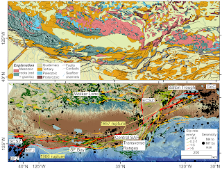
My recent attempt to follow Prof. Allen's ideas about the San Andreas Fault (some edits on the caption from Mike Oskin; we made this as a prototype for a SCEC request). The geology of the plate boundary shows the SAFS progressively dismembering the former subduction system (as indicated by the paired Mesozoic metamorphic--green and granitic--red rocks) (https://ngmdb.usgs.gov/gmna/; upper panel). This framework is a first order control on the behavior of the system (lower panel): active faults (USGS and CGS 2021) and M>4 seismicity (https://earthquake.usgs.gov/earthquakes/search/) overlain on the GMRT (Ryan, et al., 2009).

Friday, March 8, 2019

Idea for an earthquake intensity exercise based on 1857 Ft. Tejon earthquake data

I was cleaning some files yesterday and I found an old exercise I had deployed when I was first teaching Introductory Geology. It was intended to help students understand earthquake intensity (vs.) magnitude. I took the felt intensities as reported by D. C. Agnew and K. Sieh (1978), A documentary study of the felt effects of the great California earthquake of 1857, Bull. Seismol. Soc. Amer., vol. 68, pp 1717-1729 and compiled some of the more easily interpreted ones into a table and then provided a simple map of California for the students to map the intensities. Here is a link to the compiled data from Agnew and Sieh. THe work of Kerry Sieh on the 1857 earthquake is seminal. I think it was an ok exercise, but there are probably more interesting and more recent datasets. For example, I like the twitter-based work that is coming from the USGS colleagues. It should be possible to take some sample tweets and do an intensity mapping.

The 1857 earthquake and its foreshocks and aftershocks are fascinating an a sobering reminder of what will happen one day in California.

This figure from Toké and Arrowsmith, 2006 shows the 1857 foreshocks and the mainshock distribution (the latter is what the exercise mentioned in the last paragraph is supposed to look like) and compares it with the historic Parkfield earthquakes.

Monday, June 5, 2017

Some new San Andreas Fault tour videos of 1 m bare earth hillshades

I have been preparing a lecture and I built some new simple videos flying along the San Andreas Fault. The videos are made by me flying along in Google Earth with 1 m hillshades produced from lidar topography data collected along the San Andreas Fault. The videos are on youtube in this play list: https://www.youtube.com/playlist?list=PLFfZSFyNZ_jZm86F1TsnYfuuYNef_Uh21. I also put the MP4s in this folder--they are numbered 1-8 from NW-SE.

The flights follow generally along the San Andreas Fault from Point Arena to the southern Carrizo Plain (Dragon's Back and Northern Elkhorn Hills):

The data were processed at www.opentopography.org and come from 3 really cool datasets:

Thursday, March 16, 2017

Mapping landforms with applications to geomorphology and earthquake geology EXERCISE

I wanted to share a project I have developed on and off for about 10 years. It is a classroom exercise for Mapping landforms with applications to geomorphology and earthquake geology. So far, it has an example for strike-slip faults (Wallace Creek along the San Andreas Fault), and blind thrust faults (Wheeler Ridge in Southern California). I have an intention to add a normal fault example but have not finished it yet.

The basic idea is that the exercises could be done "analog"--that is on paper in a classroom. They emphasize some simple morphologic and geomorphic mapping (but on high resolution topography base maps from lidar data collected by NCALM and available for download from OpenTopography), and then provide landform ages so that students can calculate slip rate or surface uplift rates. I am not sure they are so well explained so any feed back is welcome.

Exercise material:

Friday, September 12, 2014

Southern California Earthquake Center 2014 meeting group picture

Many of my students and colleagues and I just returned from the 2014 Southern California Earthquake Center meeting. It was really great: so much energy, so many old and new friends and colleagues. It is a very strong community with a world-leading emphasis on earthquake system science. I am on the Planning Committee and was very engaged many aspects of the meeting.

Here is a fun picture from the meeting:

Back row: Kate Potter (ASU), Kendra Johnson (Colorado School of Mines), Ed Nissen ((Colorado School of Mines), Wei Zhanyu (Chinese Earthquake Administration). Front row: Emily Kleber (ASU), Barrett Salisbury (ASU), me, and Gayatri Marliyani (ASU). I am always proud of my students and associates!

I flew to Palm Springs for the meeting and on the flight home, I had a nice view of the San Andreas Fault zone in the Indio Hills just to the east of Palm Springs and the meeting location. Here are two pictures:


The main fault trace cuts diagonally across the middle of the upper view. Two large scale right lateral offsets are evident along the fault. On the right side of the lower image, secondary (normal?) faults cut the uplifted alluvial fan units.

Along the San Andreas Fault in this area the the B4 laser scan data were collected by the Ohio State University, the National Center for Airborne Laser Mapping, USGS, and UNAVCO. The data are available on line at OpenTopography. Here is a screen capture of the hillshade in google earth:


And, here is the kmz file for that area of the hillshade of the DEM I calculated at OpenTopo.

Monday, September 2, 2013

Exploring topographic response to interacting surface processes and rock uplift: the Dragon's Back Pressure Ridge along the San Andreas Fault, Carrizo Plain, CA


The Dragon's Back Pressure Ridge is an amazing landform along the San Andreas Fault in the Carrizo Plain of California. A recent paper in Science by Hurst, et al. examined it to explore how hillslope form might be used to indicate waxing and waning responses to a pulse of rock uplift. George Hilley (a coauthor on the recent paper) and I along with David Pollard and Dallas D. Rhodes have spent more than 20 years pondering and exploring the Dragon's Back. With this blog entry I want to highlight a few links for more information.

This is the main published paper on the Dragon's Back up to now: Hilley, G. E., and Arrowsmith J R., Geomorphic response to uplift along the Dragon's Back pressure ridge, Carrizo Plain, California, Geology, v. 36; no. 5; p. 367–370; doi: 10.1130/G24517A.1, 2008.

Ph.D. theses:

  • Arrowsmith, JR, 1995, Coupled Tectonic Deformation and Geomorphic Degrada tion along the San Andreas Fault Zone [Dissertation thesis]: Stanford, Stanford University.
  • Hilley, G. E., 2001, Landscape development of tectonically active areas [Dissertation thesis]: Arizona State University.

Hillshades and digital elevation model (B4 project data processed by OpenTopography):

Other links:

The digital elevation models that enabled much of the analysis discussed here come from the B4 project and the data and models are available from OpenTopography.
The B4 project created an unprecedentedly accurate surface model along the San Andreas and San Jacinto Faults in southern California that enabled the research reported here. It was supported by the U. S. National Science Foundation and led by Ohio State University and the U. S. Geological Survey. The National Center for Airborne Laser Mapping performed the airborne data acquisition and laser data processing. Optech International generously contributed use of the ALTM3100 laser scanner system. UNAVCO and SCIGN assisted in GPS ground control and continuous high rate GPS data acquisition. A group of volunteers from USGS, UCSD, UCLA, Caltech and private industry, as well as gracious landowners along the fault zones, also made the project possible.

Tuesday, January 24, 2012

Monday, August 8, 2011

Wallace Creek: New radiocarbon results and slip rate estimates of the San Andreas Fault in the Carrizo Plain

Our team along with Sinan Akciz and Lisa Grant-Ludwig from UC Irvine just finished a SCEC-supported project to re excavate a few of the trenches from the now famous work published as Sieh and Jahns, 1984 at Wallace Creek. While the slip rate of the San Andreas Fault has been well established at about 36 mm/yr from that work, it is only constrained by a few radiocarbon dates. With our experience working in the area and the enhanced capabilities of the W. M. Keck Carbon Cycle Accelerator Mass Spectrometry Laboratory  at UC Irvine, we proposed that it was time to revisit the ages of the main offset channel at Wallace Creek.

Aerial view of open excavations (photograph by Wendy Bohon, ASU)


View Larger Map


The effort was highlighted in a local newspaper: http://www.sanluisobispo.com/2011/08/07/1709285/quake-research-san-andreas-fault.html .


Here is our SCEC abstract that was just submitted (the title of this blog entry is the same):

Revisiting Wallace Creek: New radiocarbon results and slip rate estimates of the San Andreas Fault in the Carrizo Plain

S.O. Akciz, D.E. Haddad, W. Bohon, L. Delgadomendes, G. Marliyani, B. Salisbury, T. Sato, L. Grant Ludwig, J R. Arrowsmith

Sieh and Jahns (1984) determined the slip rate of the San Andreas fault (SAF) at Wallace Creek in the Carrizo Plain, and thereby provided an anchor for nearly all data-driven models of the southern San Andreas fault behavior. Their landmark study has been referenced hundreds of times and is a critical constraint in many related studies and in hazard estimates for the south-central SAF. Slip rate estimates at Wallace Creek (33.9±2.9 mm/yr) and at Van Matre Ranch site
(29.3-35.6 mm/yr; Noriega et al., 2006) agree well within measurement uncertainty, and with the 30–37 mm/yr velocity gradient across the SAF from decadal timescale geodetic measurements (Schmalzle, et al., 2006). Surprisingly, only a few detrital charcoal samples (9 samples at VMR, 8 samples at Wallace Creek) have been used to provide the absolute geochronological constraints. At a third site, Phelan Creeks, located ~ 2.5 km SE of Wallace Creek, 23 trenches were opened and over 400 charcoal samples were collected (Sims et al., unpublished data) to provide additional slip rate constraints, but the detailed study was never published.

New paleoseismologic investigations at the Bidart Fan site, ~5 km SE of Wallace Creek, indicate that southern SAF in the Carrizo Plain has apparently ruptured, on average, every 88 years (45-144 yr for individual intervals) between ~A.D. 1350 and 1857 (Akciz et al., 2010). B4 LiDAR (light detection and ranging) data analysis by Zielke et al. (2010) also found that only ~5.5 m of slip occurred along the SAF in the Carrizo Plain in 1857 and at least since ~A.D. 1400, and none of the earthquakes generated displacements larger than 5 meters (Grant Ludwig et al., 2010).

Slip per event and earthquake timing constraints can be tested against slip rate information to assess the steadiness of slip. Therefore, these new data and the geochronological limitations of the published slip-rate studies emphasize the need to improve, if not confirm, the existing slip-rate estimates by providing additional geochronological constraints. In August, 20111, we re-excavated T7 and T11 from Sieh and Jahns' study, photologged the trench walls (1:10) and collected a total of 30 new detrital charcoal samples from different stratigraphic layers from both of the trenches. Trench logs and radiocarbon results will be presented.


References:
Akciz, S.O., Grant Ludwig, L., and Arrowsmith, J R., 2009, Revised dates of large earthquakes along the Carrizo section of the San Andreas Fault, California, since A.D. 1310±30. Journal of Geophysical Research-Solid Earth, v. 114, B01313-6841.


Akciz, S.O., Grant Ludwig, L., Arrowsmith, J R., Zielke, O., 2011. Century-long average time intervals between earthquake ruptures of the San Andreas fault in the Carrizo Plain, California: Geology, v. 38, p. 787-790.


Grant Ludwig, L., Akciz, S.O., Noriega, G. R., Zielka, O., Arrowsmith, J R., 2010. Climate- Modulated Channel Incision and Rupture History of the San Andreas Fault in the Carrizo Plain: Science, 327, 5969, p. 1117-1119.


Sieh, K. E., 1977, Late Holocene displacement along the south-central reach of the San Andreas Fault, Ph.D. dissertation, Stanford University, Stanford, California, 219 pp.


Sieh, K.E., and Jahns, R.H., 1984, Holocene Activity of the San-Andreas Fault at Wallace Creek, California: Geological Society of America Bulletin, v. 95, p. 883-896.


Zielke, O., Arrowsmith, J R., Ludwig L G., Akciz, S.O., 2010. Slip in the 1857 and Earlier Large Earthquakes Along the Carrizo Plain, San Andreas Fault: Science, 327, 5969, p. 1119-1122.