Showing posts with label fault scarps. Show all posts

Friday, March 8, 2024

Remembering Thomas C. Hanks

I attended the Tom Hanks, a Remembrance symposium at the USGS in Moffett Field Oct. 17, 2024. It was a great chance to remember Tom, reflect on his vast scientific and personal impacts, and to catch up with old friends and colleagues. It was also nice to meet Tom's daughters. I was fortunate to be able to make a presentation. Here is my talk: LINK.

Here is the program from the event: LINK

~~~~~~~~~~~~~~~~~~~~~~~~~~~~~~~~~~~~~~~~~

I heard that Thomas C. Hanks passed away recently. He was a mentor to me. He worked for his career with the US Geological Survey. The memorials of him from his colleagues will be many and deep. I wanted to capture some of my memories of him. Tom was very supportive of young scientists and very broad in his scientific thinking. While he was most well known as a seismologist, his work in geomorphology and fault scarps and fragile geologic features was transformative.


This was a sticky on a manuscript draft he once gave me after a discussion on uncertainties in morphologic datting. Look at the nice handwriting (usually from a well sharpened #2 pencil). And the signature THanks.

Tom was on my Ph.D. supervisory committee. I was at Stanford and Tom was in Menlo Park at the USGS. Like many of his colleagues there, he was very generous with his time with the Stanford students. We talked a lot about fault scarps and diffusion, but also about the San Andreas Fault and I was able to drive for him on a few field trips to the SAF in the southern Bay Area into the Creeping Section. With Professor Gordon Brown's support (chair of our department at the time), Tom helped to lead an active tectonics seminar one quarter.

Tom's work on the age of scarplike landforms from diffusion-equation analysis (title of one of his latter papers on the subject) was very influential. He teamed up with Robert Wallace and others to take something simple about how fault scarps apparently change shape over time and quantify it in a realistic way. There are numerous important papers on the topic with Tom as an author but two seminal ones are:
Hanks, T. C., Bucknam, R. C., Lajoie, K. R., & Wallace, R. E. (1984). Modification of wave-cut and faulting-controlled landforms. Journal of Geophysical Research. https://doi.org/10.1029/JB089iB07p05771
and
Hanks, T. C. (2000). The Age of Scarplike Landforms From Diffusion-Equation Analysis. https://doi.org/10.1029/rf004p0313 in Quaternary Geochronology: Methods and Applications. In AGU Reference Shelf 4 (Vol. 4).

Among many other contributions on the age of scarplike landforms, Tom introduced a simple morphological dating approach: reduced slope-offset. He argued for a measure of the scarp midpoint slope (reduced by the far field slope) versus the vertical offset and he developed a nice calibration along with his colleagues for the rate constant k. He favored analytical solutions (tolerating my numerical approach).
One small anecdote that I always appreciated on the geomorphology side was his desire to name a unit for GK Gilbert (1m2/kyr = 1GKG). See the seminal 1984 Hanks et al JGR paper. It did not catch on but was a fun idea.

In 2007, David Haddad and I went with Tom to Northern Arizona University to see the collection of his father's photographs that he had endowed: Repeat Photography Site for The James J. Hanks Photographs, 1927-1928. Tom, like always, was deeply engaged/obsessed with the topic at hand. He worked hard to relocate and repeat his father's photographs, as well as to tell their story.

Whilst on the trip to Flagstaff, Tom, David, and I stopped to see and discuss the Granite Dells (near Prescott, AZ). Tom had been leading parts of the seismic hazard analysis for the Yucca Mountain possible nuclear repository. The problem they were coming up with was the age of the landscape was great (million year old landforms) and there were fragile geologic features and precarious rocks that may have been there fragile for a large fraction of that time. However, the extrapolation of the ground motion predictions would be to extreme, possibly unrealistic levels. Tom was interested in these million-year-old landscapes of fragile geologic features and recognized their value as an observational constraint for seismic hazard analysis. This is an impressive product of their work:
Hanks, T. C., Abrahamson, N. A., Baker, J. W., Boore, D. M., Board, M., Brune, J. N., Cornell, C. A., & Whitney, J. W. (2012). Extreme Ground Motions And Yucca Mountain. Extreme Ground Motions and Yucca Mountain Open-File Report 2013–1245, US Geological Survey.

Tom was interested in precariously balanced rocks given their use as a part of seismic hazard analysis. He thought it might be helpful for new people to get involved. So, he pulled David and I into it. He was supportive and helped generate some funds for us. That lead to a couple of nice papers lead by David. I regret that we did not have Tom as a coauthor:
Haddad, D. E., Akciz, S. O., Arrowsmith, J. R., Rhodes, D. D., Oldow, J. S., Zielke, O., Toke, N. A., Haddad, A. G., Mauer, J., & Shilpakar, P. (2012). Applications of airborne and terrestrial laser scanning to paleoseismology. Geosphere, 8(4). https://doi.org/10.1130/GES00701.1
Haddad, D. E., Zielke, O., Arrowsmith, J. R., Purvance, M. D., Haddad, A. G., & Landgraf, A. (2012). Estimating two-dimensional static stabilities and geomorphic settings of precariously balanced rocks from unconstrained digital photographs. Geosphere, 8(5). https://doi.org/10.1130/GES00788.1

A final lesson from Tom is that senior scientists should be generous and use their privilege to do good. Tom was a widely appreciated mentor of younger scientists--men and women. He was also a leader who did not shy away from trying to do the right thing. Just one example relates to another senior scientist who recently passed away: Paul Tapponier. Professor Tapponier led a transformation of our understanding of continental tectonics. He favored results with relatively high slip rates and thus the inference that the deformation even in plate interiors was more plate-like. Tom supported his colleague Wayne Thatcher who had come up with a result based on geodesy for the deformation of the Asian continental interior (Thatcher W. 2007. Microplate model for the present-day deformation of Tibet. J. Geophys. Res. 112:B01401) (and that did not sit well with Paul). Zack Washburn and I had written a paper based on paleoseismology in which we could not support enough earthquakes to support a high slip rate). Tom stepped in to mediate between Wayne and Paul and consulted me as part of his preparations. Tom had the stature, the intelligence, maturity and deserved respect so that he was able to set the tone for what I gather was a productive meeting.

I ended up with a copy of Tom's USGS bio and I note the following which is a nice example of his writing and matter-of-fact approach:

Monday, December 27, 2021

Eminent earthquake scientists: Clarence Allen and Robert Wallace oral histories

For some "light reading" over the winter break, I have enjoyed a read of oral histories of Clarence Allen (Caltech) and Robert Wallace (USGS).
EARTHQUAKES, MINERALS AND ME: WITH THE USGS, 1942-1995 by Robert E. Wallace; Oral History Interviews With Stanley Scott; USGS Open-File Report 96-260

Connections EERI Oal History Series: Clarence Allen with interviewer Stanley Scott
CLARENCE R. ALLEN (1925-2021) INTERVIEWED BY DAVID A. VALONE Caltech archives. This latter one has a bit more about Caltech and is slightly less polished than the first.

Maybe I at times too sentimental, but I found these personal and scientific histories throught provoking and inspiring, not only for their tellings of important steps in the history of earthquake science and service, but also for their modest, laconic, and matter of fact story telling. I am also fortunate to have substantial memories of interacting with both of them personally and also of the transition at the end of their careers and the beginning of mine (I entered graduate school at Stanford University in Fall 1989). I also appreciate the effort of EERI to accumulate those and other oral histories.

One thing that comes to mind is that it would be nice to include some histories from women who have contributed in these areas. I will work on that for a future blog post.

Bob Wallace was inspiring as an earthquake geologist. I followed some of his work quite closely as I shared an obsession with geomorphic indicators of faulting, although certainly with less of an impact...
Just a couple of examples from his papers:

  1. 1949 - Wallace, R. E., Structure of a portion of the San Andreas rift in southern California: Bulletin of the Geological Society of America, v. 60, n. 4, p. 781-806.. This is cited as one of the earliest focused mapping efforts along the San Andreas Fault. He mapped substantial offset along the San Andreas Fault and also worried about the fault zone core and interactions of the drainage network with the fault zone. At one point, I colored the detailed map to appreciate it better.
  2. 1968 - Wallace, R. E., Notes on stream channels offset by the San Andreas fault, southern Coast Ranges, California, in Dickinson, W. R., and Grantz, Arthur, eds., Proceedings of conference on geologic problems of San Andreas fault system: Stanford University Publications in Geological Science, v. 11, p. 6-21.. This was a landmark in my mind as he noted offsets along the San Andreas Fault in the Carrizo Plain as indicators of short and longer term indicators of recurrent fault slip. It was in a somewhat difficult to find publication. But, being around Stanford University (and having to move out of the Geology Corner after the Loma Prieta Earthquake), there were numerous copies to be found. Figures 6 and 7 of the histograms of numbers of channels with certain offset sizes was something we followed up on a fair bit.
  3. 1990 - Wallace, R. E., (editor) The San Andreas Fault System, California: U. S. Geological Survey Prof. Paper 1515, 283 p.. This was his magnum opus. I was lucky once to meet him in his office at USGS Menlo Park and he asked if I had a copy yet. I did not even though I had stared at it. He reached into his filing cabinet and gave me his copy! I should have asked him to sign it or something but I certainly treasure that copy. It has now been rebuilt a few times...
  4. 1992 - Wallace, R. E., Ground-squirrel mounds and patterned ground along the San Andreas fault in central California: U. S. Geological Survey, Open-file report n.91-149, p. 1-21.. This was a modest contribution, but I had a couple of conversations with him about it as we shared our enthusiasm for the Carrizo Plain. In his related GSA presentation, he even mentioned me as someone who might pick it up! Scared the crap out of me. We never really did a systematic effort on this but it remains a fascinating problem. I talk about it with people every time I get to the Carrizo Plain.
THere is a lot more to say and remember about Bob Wallace. My memories of him are also tied to Kerry Sieh who worked with Bob and honored him by naming the offset channel he explored in the 1968 paper "Wallace Creek". How many times have I read the Sieh and Jahns 1984 paper: Sieh, K. E., and Jahns, R. H. (1984). Holocene activity of the San Andreas fault at Wallace Creek, California. Geological Society of America Bulletin, 95, 883–896.. We even revisited this in our 2019 paper.

One of my San ANdreas Fault tour videos over the Carrizo Plain. Hillshades produced by me from the B4 project at OpenTopography.

I did not interact with Clarence Allen as much as I did with Bob Wallace, but I did have a few nice conversations with him. I think he was more serious in the conversations than I was. They main ones were when I was thinking about going to Caltech to work with Kerry Sieh. Clarence and I talked about science, but also about trout fishing. I regret never taking him up on an invite to fish in the San Bernardino Mountains. I think my father had fished some of the same places there around and below Lake Arrowhead or Big Bear Lake.
Two papers among many I would like to highlight from Clarence:

  1. Allen, C. R. (1968). The tectonic environments of seismically active and inactive areas along the San Andreas fault system. Proceedings of Conference of Geologic Problems of San Andreas Fault System, 5(1496), 70–80.. This stands as an important first order characterization of the San Andreas Fault system and the recognition that the geology was an important control on the current behavior of the system. I have used Figure 1 here and there over the years when I kick of talks on the San Andreas Fault.
  2. Geological Criteria for Evaluating Seismicity: Address as Retiring President of The Geological Society of America, Miami Beach, Florida, November 1974 CLARENCE R. ALLEN GSA Bulletin (1975) 86 (8): 1041–1057. This is a classic that helps to introduce the concepts of earthquake geology and the value of the geologic record in the study of recently active faults.
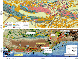
My recent attempt to follow Prof. Allen's ideas about the San Andreas Fault (some edits on the caption from Mike Oskin; we made this as a prototype for a SCEC request). The geology of the plate boundary shows the SAFS progressively dismembering the former subduction system (as indicated by the paired Mesozoic metamorphic--green and granitic--red rocks) (https://ngmdb.usgs.gov/gmna/; upper panel). This framework is a first order control on the behavior of the system (lower panel): active faults (USGS and CGS 2021) and M>4 seismicity (https://earthquake.usgs.gov/earthquakes/search/) overlain on the GMRT (Ryan, et al., 2009).

Thursday, December 31, 2020

Exploring diffusion for hillslope changes using a spreadsheet

I became obsessed with diffusion erosion modeling in my PhD work. It is a simple (certainly oversimplified) way to think about how hillslopes may change over time in the absence of mass wasting, debris flow, and fluvial processes. There is a lot to say about it, but I wanted to capture a few items I recently developed.

Here is an explanation and assignment on the topic in my Computers in Geology class: Lecture 8: Exploring diffusion using Excel.

One of the challenges that I have had in some applications is that the computational "space" was too small in the spreadsheet, given that it is fixed. Of course this is not a problem if one dynamically determines the number of time steps for example based on a stability criterion and you do it with a for or while loop in something like Matlab. So, when I was helping Emily Apel with her senior thesis recently, I built her a big spreadsheet (seemed easier given the limited time that she had.

Here is the original spreadsheet with only 27 space steps and 191 time steps. It is good for teaching and quick demos: LINK to Spreadsheet.

Above is the screen cap of the main interface page where the user just changes the bold cells and watches the calculations in real time.
Above is the screen cap of the Model Calculation Space tab which shows the compuational engine with its fixed elevation boundary conditions and explicit centered in space and forward in time finite differences.

Here is the big spreadsheet with 250 space steps and 1000 time steps: LINK.

And, here is a video that I built to explain the general activity for Emily Apel, but it may be useful for others. It explains the two spreadsheets that are linked above.

One of the cirtical concepts that is accessible in both of these spreadsheets is the opportunity explore not only initial step models, but also continuously displaced scenarios.

Here are a few other blog posts and recent publications which might be of interest as well:

Wednesday, March 18, 2020

Accumulating links for today's southern Salt Lake Utah area earthquake (M5.65 earthquake 4km NNE of Magna, Utah: 03/18/2020 6:09:31 AM AZ time)

A M5.7 earthquake occurred this morning and it was widely felt along the northern Wasatch Front. Numerous aftershocks have occurred and will continue. Its characteristics are consistent with the crustal extension occurring in the region (Basin and Range).

I am accumulating some links here:

Monday, February 25, 2019

Updated review of fault scarp analysis

I am organizing for a presentation to my research group on fault scarp analysis. This is an ongoing obsession of mine. I have blogged about this topic here with some review. That is still a pretty good summary of things. I also have a couple of relevant Landers Earthquake posts here and here. And, we applied many of the relevant tools to analysis of cinder cone forms.

The 2017 post mentioned above is still a pretty good summary of things. However, the MATLAB-based guis for Penck1D and Scarpdater are not running well now on newer versions of MATLAB; they need an overhaul. We were really into guis back then but they require so much code relative to the actual modeling. Might be cool to rewrite in Jupyter notebooks, maybe see how much in landlab could be used.

I have prepared a new review powerpoint (PPT and PDF) with this outline:

  • Introduction and review
  • Diffusion-equation analysis of scarplike landforms
  • Observations
    • Direct dating of fault scarps
    • Fault scarp erosion monitoring
  • Modeling
    • Distributed deformation
    • Transport vs. Production limited
  • Extending processes 2D and nonlinear diffusion
  • Prospects and cautions
Of course it is incomplete and emphasizes the work of my students and colleagues. I note for example, this nice review from Wei, et al., Journal of Asian Earth Sciences, 2015:

Additional resources for my lecture include:

Some other useful web links include: